File:Tile to latlon.png
Jump to navigation
Jump to search

Size of this preview: 800 × 320 pixels. Other resolutions: 320 × 128 pixels | 640 × 256 pixels.
Original file (1,500 × 600 pixels, file size: 41 KB, MIME type: image/png)
Summary
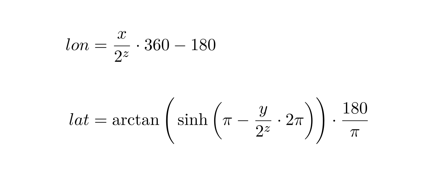
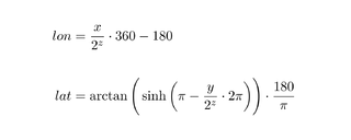
Formulas to convert tile x,y coordinates into latitude and longitude. Based upon File:Lonlat_tile.JPG.
\begin{align*}
    lon &= \frac{x}{2^z} \cdot 360 - 180 \\ \\
    lat &=
        \arctan \Bigg(
            \sinh \bigg( \pi - \frac{y}{2^z} \cdot 2\pi \bigg)
        \Bigg) \cdot \frac{180}{\pi}
\end{align*}
Licensing
![]()
This file has been released into the public domain by the copyright holder, its copyright has expired, or it is ineligible for copyright. This applies worldwide.
Please, please use more specific template such as {{PD-self}} / {{PD-creator}} / {{PD-shape}} / {{PD-USGov}} / {{PD-old}} / {{PD-RU-exempt}} ... This template is not making clear why this work is in the public domain.
Please, please use more specific template such as {{PD-self}} / {{PD-creator}} / {{PD-shape}} / {{PD-USGov}} / {{PD-old}} / {{PD-RU-exempt}} ... This template is not making clear why this work is in the public domain.
File history
Click on a date/time to view the file as it appeared at that time.
| Date/Time | Thumbnail | Dimensions | User | Comment | |
|---|---|---|---|---|---|
| current | 14:06, 9 May 2013 | 1,500 × 600 (41 KB) | SammysHP (talk | contribs) | Formulas to convert tile x,y coordinates into latitude and longitude. Based upon File:Lonlat_tile.JPG. \begin{align*} lon &= \frac{x}{2^z} \cdot 360 - 180 \\ \\ lat &= \arctan \Bigg( \sinh \bigg( \pi - \frac{y}{2^... |
You cannot overwrite this file.
File usage
The following 3 pages use this file: