File:TrackVsStreet.png
Jump to navigation
Jump to search

No higher resolution available.
TrackVsStreet.png (176 × 220 pixels, file size: 4 KB, MIME type: image/png)
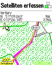
The image shows a track rendered below a street.
Device was a Garmin Etrex Vista Hcx. Map source was one of Computerteddy's maps 12 years ago (2010) and also it did happen on other osm maps. It was a screenshot from the device. More info in the user talk at computerteddy.
Licensing
- This media file was uploaded by author of the work and its copyright holder.
![]()
![]()
![]()
This work is licensed under the Creative Commons Attribution-ShareAlike 4.0 License.
Attribution: Waldkater
Attribution: Waldkater
![]()
Contains map data © OpenStreetMap contributors, made available under the terms of the Creative Commons Attribution-ShareAlike 2.0 (CC-BY-SA-2.0).
File history
Click on a date/time to view the file as it appeared at that time.
| Date/Time | Thumbnail | Dimensions | User | Comment | |
|---|---|---|---|---|---|
| current | 19:09, 7 February 2010 | | 176 × 220 (4 KB) | Waldkater (talk | contribs) | The image shows a track rendered below a street. |
You cannot overwrite this file.
File usage
The following page uses this file: