File:Tree-density.png
Jump to navigation
Jump to search


Size of this preview: 600 × 600 pixels. Other resolutions: 240 × 240 pixels | 480 × 480 pixels | 768 × 768 pixels | 1,024 × 1,024 pixels | 1,600 × 1,600 pixels.
Original file (1,600 × 1,600 pixels, file size: 761 KB, MIME type: image/png)
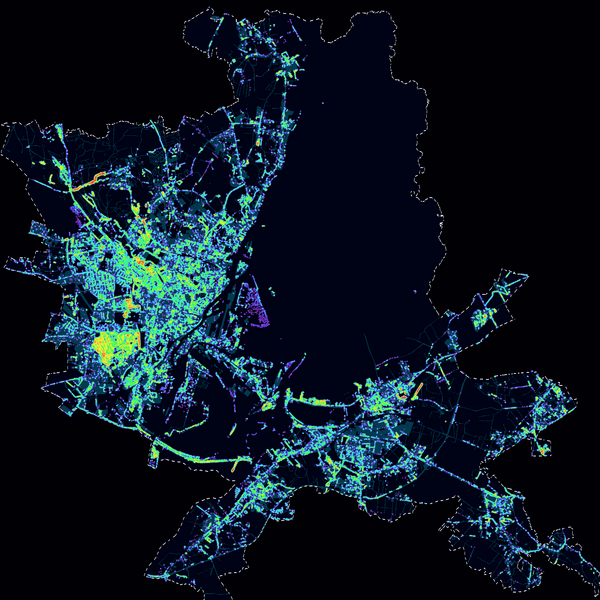
Heat map with natural=tree's plotted in Szczecin. Data obtained from the same source as the building outlines, by scanning the map for the tree icons. The map is a bitmap layer generated from vector data but OSM only received access (and permission) to use the bitmaps.
This is a Featured image, which means that it has been identified as one of the best examples of OpenStreetMap mapping, or that it provides a useful illustration of the OpenStreetMap project. If you know another image of similar quality, you can nominate it on Featured image proposals.
Front-page image for week 31 of 2010 (2–8 Aug.).
- Image descriptions
- English : Distribution of natural=tree nodes in Szczecin obtained from the city's cadastre bureau. (Project of the week/2010/Aug 01 is to add more)
- français : Heat map montrant la distribution des points natural=tree à Szczecin obtenus à partir du cadastre de la ville.
- italiano : Distribuzione dei nodi di tipo natural=tree nella città di Stettino (Polonia), ottenuti dagli uffici catastali del comune. (Tramite il progetto della settimana 01/Ago ne verranno aggiunti altri)
- lietuvių : Taškų natural=tree pasiskirstymas mieste Szczecin, Lenkijoje. Duomenys paimti iš miesto kadastro.
- magyar : Hőtérkép mutatja a natural=tree pontok eloszlását Szczecinben. Az adatok a városi földhivataltól származnak. (A hét projektje/2010/Aug 01, hogy több legyen bejelölve)
- polski : Rozkład drzew (czyli węzłów natural=tree) w Szczecinie, dane otrzymano od Urzędu Miasta. Więcej o mapowaniu drzew na stronie Projekt Tygodnia/2010/1 sierpnia.
- русский : Карта распределения точек деревьев natural=tree в Щецине, Польша (Szczecin), данные для которой получены в городском кадастровом бюро
File history
Click on a date/time to view the file as it appeared at that time.
| Date/Time | Thumbnail | Dimensions | User | Comment | |
|---|---|---|---|---|---|
| current | 16:42, 30 May 2010 | | 1,600 × 1,600 (761 KB) | Balrog (talk | contribs) | Heat map with natural=trees plotted in Szczecin. Data obtained from the [http://gis.um.szczecin.pl/ same source] as the [[File:Szczecin-gis-footprints.png|building outlines], by scanning the map for the tree icons. T |
You cannot overwrite this file.