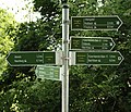
File:Wanderwegweiser Saale-Unstrut bei Almrich.jpg

From OpenStreetMap Wiki
Jump to navigation Jump to search

Original file(4,660 × 4,000 pixels, file size: 5.06 MB, MIME type: image/jpeg)

View on Wikimedia Commons
This file and its description are from Wikimedia Commons.

Summary

Description
Deutsch: Wanderwegweiser nahe Almrich bei Naumburg im Saale-Unstrut-Gebiet. Für jeden markierten Wanderweg gibt es eigene, grüne Wegweiser. Zudem wird eine Wanderverbindung ohne Name und Symbol ausgewiesen.

Es werden jeweils der nächste Ort und das nächste größere Ziel ausgewiesen und Entfernungen in Kilometer angegeben. Orte mit Bahnanschluss werden durch ein Symbol gekennzeichnet. Name und Symbol des Wanderwegs sind im Wegweiser integriert. Die Befestigung der Wegweiser am Metall-Schildermast ist unterschiedlich robust ausgeführt. Sie erfolgt mittels Spannbänder.

Im Bild ausgewiesene Wanderwege: "Weinbergsweg", grüner Punkt, Rundweg um Bad Kösen "Feengrotten-Kyffhäuser-Weg", blauer Strich nach Bad-Kösen/Freyburg

Namenlose Wanderverbindung ohne Symbol nach Naumburg
Date
Source Own work
Author Jochen Böttcher
Camera location51° 09′ 21.68″ N, 11° 45′ 33.62″ E Kartographer map based on OpenStreetMap.View this and other nearby images on: OpenStreetMapinfo

Licensing

I, the copyright holder of this work, hereby publish it under the following license:
w:en:Creative Commons
attribution share alike
This file is licensed under the Creative Commons Attribution-Share Alike 4.0 International license.
You are free:
  • to share – to copy, distribute and transmit the work
  • to remix – to adapt the work
Under the following conditions:
  • attribution – You must give appropriate credit, provide a link to the license, and indicate if changes were made. You may do so in any reasonable manner, but not in any way that suggests the licensor endorses you or your use.
  • share alike – If you remix, transform, or build upon the material, you must distribute your contributions under the same or compatible license as the original.

Captions

Add a one-line explanation of what this file represents

26 June 2021

51°9'21.676"N, 11°45'33.617"E

0.00666666666666666666 second

55 millimetre

image/jpeg

File history

Click on a date/time to view the file as it appeared at that time.

Date/TimeThumbnailDimensionsUserComment
current19:21, 28 October 2021Thumbnail for version as of 19:21, 28 October 20214,660 × 4,000 (5.06 MB)wikimediacommons>Jochen BöttcherUploaded own work with UploadWizard

Metadata