File:WikiData C19th Aberystwyth shipwrecks.jpg

Original file (1,878 × 966 pixels, file size: 293 KB, MIME type: image/jpeg)
Summary
Image shared on twitter https://twitter.com/WIKI_NLW/status/786862751436144640 by Jason Evans (WikiData user, "open advocate and history buff")
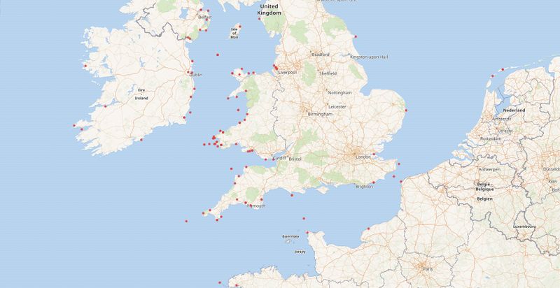
This is a screenshot of a WikiData query presented on a map described as "Map of C19th #Aberystwyth ships wrecked at sea, using data from @NLWales & @CeredigionArch"

Front-page image for week 45 of 2016 (7–13 Nov.).
- Image descriptions
- English : The WikiData project has an eclectic mix of linked datasets and provides a querying interface which can yield a map. This example by Jason Evans shows positions of 19th century Aberystwyth ships wrecked at sea, using data from National Library of Wales and the Ceredigion Archives.
- italiano : Il progetto WikiData ha un miscuglio eclettico di dataset collegati e fornisce un'interfaccia di ricerca che può produrre una mappa. Questo esempio di Jason Evans mostra le posizioni delle navi di Aberystwyth naufragate nel 19° secolo, usando dati della National Library of Wales e dei Ceredigion Archives.
- русский : Проект Викиданные объединил и структурировал огромное разнообразие связанных между собой данных. Записи геопривязкой легко визуализировать на любой карте. На этом примере от Джейсона Эванса показаны места крушения кораблей из английского города Аберистуит в 19 веке. Данные взяты из Национальной библиотеки Уэльса и архива города Кередигион.
- 中文(简体) : WikiData专案具有混合组合的连接资料集,并且提供可以产生地图的查询界面。 Jason Evans的这个例子,使用威尔士国家图书馆和锡尔迪金档案库资料,显示19世纪阿伯里斯特威斯船在海上失事的位置。
- 中文(繁體) : WikiData專案具有混合組合的連接資料集,並且提供可以產生地圖的查詢界面。Jason Evans的這個例子,使用威爾士國家圖書館和錫爾迪金檔案庫資料,顯示19世紀阿伯里斯特威斯船在海上失事的位置。
Licensing
| Contains map data © OpenStreetMap contributors, made available under the terms of the Open Database License (ODbL).
The ODbL does not require any particular license for maps produced from ODbL data, produced maps may be subject also to other licences. |
The "author" of this image, Jason Evans, seems happy with a CC BY-SA license [1] though it's probably more complicated than that...
The base map is wikimedia's OpenStreetMap Tile Server and all data presented is open licensed data.
File history
Click on a date/time to view the file as it appeared at that time.
| Date/Time | Thumbnail | Dimensions | User | Comment | |
|---|---|---|---|---|---|
| current | 10:33, 7 November 2016 | | 1,878 × 966 (293 KB) | Harry Wood (talk | contribs) | Image shared on twitter https://twitter.com/WIKI_NLW/status/786862751436144640 by Jason Evans (WikiData user, "open advocate and history buff") This is a screenshot of [https://query.wikidata.org/embed.html#%23defaultView%3AMap%0ASELECT%20%3Fship%20%3... |
You cannot overwrite this file.
File usage
The following 14 pages use this file:
- Featured images/Oct-Dec 2016
- List of featured images/2016
- Uk:Featured images/Oct-Dec 2016
- Zh-hans:Featured images/Oct-Dec 2016
- Zh-hant:Featured images/Oct-Dec 2016
- File:WikiData .jpeg (file redirect)
- Template:Featured image d4
- Template:Iotw image/2016-45
- DE:Featured images/Oct-Dec 2016
- FR:Featured images/Oct-Dec 2016
- ES:Imágenes destacadas/Oct-Dic 2016
- IT:Featured images/Oct-Dec 2016
- RU:Featured images/Oct-Dec 2016
- JA:Featured images/Oct-Dec 2016