User:FrViPofm/Project of the Week
Confectionery

It was a magical place when we were younger. A place full of sweet scents, that lead to sticky fingers and perhaps a bit of stray sugar on a cheek. It was exciting to be going there and disappointing to have to leave.
You can make an excuse to revisit that place of happy memories, new flavor discoveries and a tiny little bit of sugar-inspired energy. The Project of the Week is to map your local candy store.
Tagging suggestions
A confectionery can be mapped as a node or an area.
Required tags
The only required tags for a confectionery are
- shop=confectionery
- name=*
- building=yes # for a candy store building outline.
Optional tags
Add addressing information for the store as well.
Wheelchair accessible?
- wheelchair=yes/no/limited
Results
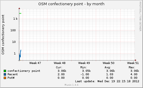
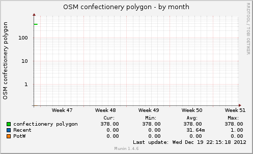
These graphs show the number of shop=confectionery objects* in the OpenStreetMap database and are updated approximately once per hour.
The results of the confectionery PotW from 2-8 Feb 2011 were modest and still made a noticeable difference in the database. Approximately 50 confectionery points and 5 polygons were added during the PotW. Keep mapping your Candy stores!
http://rweait.dev.openstreetmap.org/osmconfectpt-month.png
http://rweait.dev.openstreetmap.org/osmconfectpol-month.png
- The "recent" line shows the number of objects added recently. It is a rough indication of PotW activity over the last little while, nominally an hour. The "PotW" line indicates the start and end of the project period. It is imperfect and still manages to be fun.