MAPCAT
| It seems that MAPCAT is no longer available. |
MAPCAT (mapcat.com) is an OpenStreetMap-based world map portal launched in 2017, with the aim of offering easy-to-use tools for the OSM community even on-the-go, and thus opening up the world of OSM to new users as well.
Key functions:
Custom-made, OSM-based worldwide map API for public websites, internal systems or mobile apps.
Key features to highlight:
- Multi-language search to find locations by address, street, zip-code, settlement, POI, shapes, coordinates
- Geocoding and reverse geocoding
- POI management: 5 POI types can be visualized at a time, Wikipedia POI info and pictures integrated, advanced POI search
- I18n: maps in your own language or any preferred language
- Turn-by-turn directions for cars, with/without highways, ferries
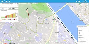
- Routing for cyclist with elevation profiles
- Map matching services, asset tracking
- Downloadable geodata in shape files, OpenLR, vector tiles, or in other GIS formats
MAPCAT's services provide an alternative mapping solution to Mapzen.
Company info:
GLI Solutions (gli-solutions.com) is a Hungarian startup founded in 2013 by serial entrepreneurs, a group of professionals with decades of GIS, business development and technology experience.
We develop innovative ICT solutions based on GIS, supporting the implementation of the Smart City concept. Keeping up with the fast growth of the sector, we continuously widen our portfolio of products and services, never stop seeking for new development opportunities, following the international and local trends in this fast-growing industry. Our portfolio of products and services offers solutions supporting intelligent traffic systems, smart infrastructure operations, and GIS based data warehousing.
Our local experience has been captured in a Hungarian public map portal, térképem.hu, that is aggregating our own map database with OSM data.
