OpenHistoricalMap/Tags/Key/start_date
 |
| Description |
|---|
| Exact date when the feature came into existence. |
| Group: lifecycle |
| Used on these elements |
| Useful combination |
| See also |
| Status: de facto |
| Tools for this tag |
This key indicates when the feature came into existence, for example when a settlement was founded, a building was built, a shop opened for business, or a tree was planted. It follows a basic format similar to ISO 8601-1.
You should always add start_date=* to every feature, other than perhaps natural features. Otherwise, data consumers handle a feature without a start date as if it started at the beginning of time.
How to map
Set start_date=* to the start date in YYYY, YYYY-MM, or YYYY-MM-DD format. Only include the day if you know the specific day, and only include the month if you know the specific month. For backwards compatibility, do not use other ISO 8601 syntaxes, such as week numbers or times of day. Instead, set start_date=* to the most accurate date you can express in the supported format, then use start_date:edtf=* to qualify the start date in the more flexible EDTF format (which also supports seasons, approximation, and uncertainty).
In ISO 8601, dates are calculated according to the proleptic Gregorian calendar. If your source indicates the start date in a calendar other than the Gregorian calendar, such as the Julian calendar, convert it to Gregorian before entering it into OpenHistoricalMap. If there the conversion is unintuitive or unambiguous, add a start_date:note=* tag explaining the conversion you performed. The proleptic Gregorian calendar records the year 1 BCE as 0000, 2 BCE as -0001, and so on.
More specifically, the start date is the date from which the feature and all its tags are accurate. You can create another copy of the feature to represent its earlier stages. For example, a building=construction starts on the day the construction crew breaks ground on the building and ends when the building is completed, while an otherwise identical building=yes starts on the day the building is completed, and an identical building=yes across the street represents the building after it was moved; a chronology relation ties the three representations together. Meanwhile, a tourism=museum inside it starts on the day the museum is dedicated.
To indicate that a feature has not yet come into existence, set its start_date=* to a date in the future. Use start_date:edtf=* in case of any uncertainty, but do not speculate on your own.
Examples

start_date=1903
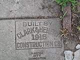
start_date=1916

start_date=1911 on the chronology relation
start_date=1925 on the building
start_date=1870-07-04

start_date=1938 on the school building and high school POI
start_date=1967 on the elementary school POI in the same location
start_date=1999 on the commemorative plaque


Software support
The OpenHistoricalMap website has a time slider that dynamically filters features on the map based on start_date=* and end_date=*. It supports values from -4000-01-01 (January 1, 4001 BCE) through December 31 of the current year.
The modified iD editor has a Start Date field that sets start_date=*; it appears for every selected feature, regardless of its feature type. A validation rule automatically checks whether the value is well-formed and also whether any features overlap both spatially and temporally. A date filter shows and hides features based on start_date=* and end_date=* for convenience. Each feature's label includes its start_date=* and end_date=*; these labels appear on the map, in relation dropdown lists, validator warning messages, and in the Save panel's list of changes. [1]