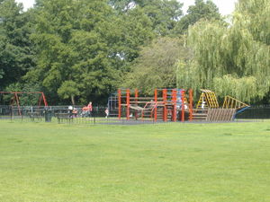
Tag:leisure=playground
| Description |
|---|
| A playground: an area designed for children to play. |
| Rendering in OSM Carto |
| Rendering in OSM Carto |

|
| Group: leisure |
| Used on these elements |
| Useful combination |
| Status: approved |
| Tools for this tag |
|
Marks a children's playground, playpark, or play area. These are outdoor (sometimes indoor) areas specifically designed for children to play. Often they provide equipment such as swings, slides, climbing frames and roundabouts. They are often part of a larger park, but are also found in residential areas and schools.
In the United States, it is common for a park to have "Playground" in its name even though there are athletic fields and other amenities in addition to the playground. Use leisure=park for the overall "Playground" and leisure=playground for the play area specifically.
In British English, it is common to refer to a school yard as a playground. Use leisure=schoolyard for open areas in schools used for recreation but usually without playground equipment.
How to map
Create an area of the grounds and tag it leisure=playground.
If you are not sure of its border you can place a single node in the middle and tag it leisure=playground, but the area is preferred.
Tags used in combination
- name=* - name of the playground
- surface=* - grass, sand, rubbercrumb, woodchips, etc.
- wheelchair=yes/no/limited if the equipment can be used by wheelchair users
- min_age=* Minimum age of the user in years
- max_age=* Maximum age of the user in years
- operator=* - e.g., the name of the local council or school
- opening_hours=*
- access=private/customers for playgrounds unavailable to public. access=yes is not necessary, but often used to explicitly mark playgrounds as publicly accessible.
- indoor=yes for indoor playgrounds (outdoor is default)
- fee=yes when entrance is charged (typical for indoor situations)
- supervised=yes for places where non-parental supervision of children is provided (no is default)
- playground:theme=* and more rarely theme=*
Playground equipment
Equipment and features within the playground should be mapped individually as separate nodes/areas, details are found here: playground=*.
Fewer mappers prefer to describe the available equipment as a summary list with prefix-tags described in playground:=*.
Additional features
- amenity=bench
- leisure=picnic_table on a node, refers to a picnic bench. On an area including multiple elements, use tourism=picnic_site - see Tag:leisure=picnic_table
- natural=tree
- amenity=waste_basket
- amenity=toilets
- barrier=fence or barrier=wall for the perimeter
- barrier=gate for a node on the perimeter
- playground=* for a detailed mapping of the installations within the playground.
Photos

Similar tags
- leisure=fitness_station - outdoor exercise equipment. A playground for adults!
- leisure=pitch - a sports pitch. An area (or "grounds") in which sports are "played", but playgrounds are more for children to play and not for serious sports.
- leisure=park - a park. Usually a park will be mapped as an area, and a playground can be placed within it.
- leisure=schoolyard - for paved open areas in schools where pupils spend breaks between lessons; for recreation but usually without playground equipment.
- tourism=theme_park - A theme park has supervised "rides", unlike playgrounds which have self-operated play equipment.
- landuse=recreation_ground - An open green space for general recreation.
- leisure=indoor_play - indoor play areas designed for pre-teen children. Please note that this tag is controversial as it can be expressed with leisure=playground plus indoor=yes.
- amenity=childcare - places where children are looked after
