Proposal:Crannog2
| crannog | |
|---|---|
| Proposal status: | Abandoned (inactive) |
| Proposed by: | B-unicycling |
| Tagging: | site_type=crannog |
| Applies to: | node, way, relation |
| Definition: | A crannog is a prehistoric or later mostly or wholly artificial island/ islet created for human habitation. In some cases, a modern re-creation for educational purposes. |
| Statistics: |
|
| Draft started: | 2022-10-25 |
Proposal
See Tag:site type=crannog (in use)
Rationale
Crannogs are a type of settlement going back as far as prehistoric times in the shape of artificial islands in Ireland, Scotland and Wales. Some had castles built on top in the Middle Ages, and some were inhabited as late as the 18th century (AD)[1]. They are found in lakes (water=lake), in wetlands (natural=wetland) and some even off the coast in the sea.
There are an estimated number of 2,000[2] crannógs in Ireland (110 are recorded in Co. Leitrim alone[3]), and that there 347 listed monuments for Scotland[4]. This would make these heritage features relevant enough to warrant their own tag.
Some of them turn out not to be crannogs after all after archaeological excavations, so it is up to each mapper to make a judgement call to map it as an archaeological site or not depending on the available information.
They can be found through local knowledge or historic maps (for example the British War office map for Ireland shows them). Other resources to find them:
Tagging
Crannogs can be recognized on satellite imagery as an island with a circular (tree) outline or as circular features in the water. Sometimes, they are now on dry land due to changes in water level and could be mistaken as ringforts or similar land structures.
Reconstructed crannogs usually have one or more roof:material=thatch huts built on them.
| tag | explanation |
|---|---|
| place=islet | If still visible above water. Note that due to the elements working on the site over the centuries, the islet might not be of the same size as the crannog and should be mapped separate. |
| historic=archaeological_site | Use for genuine sites as well as reconstructions, because they fall under experimental archaeology |
| Sub-classify site as crannog. |
| tag | explanation |
|---|---|
| historic:civilization=* | Depending on when they were built (if known). For modern reconstructions, use historic:civilization=modern |
| heritage=* | If certified as heritage. Use additional references according the the country applicable, where available, for example ref:IE:smr=*. |
| access=* | These might be vulnerable sites, often on private land, so please indicate if they are accessible to the public or not. |
Some have been built in modern times as heritage/ visitor sites, often near original sites and should have that marked with the addition of tourism=attraction.
Examples
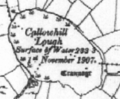
A crannog(e) in Co. Leitrim on the British War office map
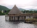
A reconstructed crannog near Kenmore, Perth and Kinross, on Loch Tay, Scotland (show on OSM). The roundhouse burnt down in 2021, unfortunately.

Loughbrickland Crannóg in Northern Ireland (show on OSM)

Crannog and wood-turning, Irish National Heritage Park, Co. Wexford, Ireland (show on OSM)

Reconstruction of a crannog in Craggaunowen, Co. Clare (show on OSM)


Rendering
Like a historic site or tourist attraction, depending on what is the case.
Features/Pages affected
Further information
- Time Team Episode on a crannog in Scotland (see on OSM)
- Crannog on Wikipedia
- Crannogs in Irish folklore (duchas.ie)
- Prehistoric pile dwellings around the_Alps
References
External discussions
Comments
Please comment on the discussion page.