Proposal:Railbed
Description
A Railbed, in the life cycle of a railway is between disused (rails remain and currently displayed) and abandoned (rails lifted and not currently displayed). The term equates more to what is visible and thus more aligned to mapping. The intention that an abandoned railway would still not render but railbed would subtly display and the usage would be more prevalent in remoter areas rather than major cities/towns. Built up areas could still use the abandoned tag where very little remains.
Why should we tag them?
Remote communities expanded due to the railway. To remove the railway completely out of the map denies the user to understand the reason for the kink in the road, the almost abandoned town or the large buildings / warehouses /silos. It allows
Rail trail developers access to displayable data
Visitors the ability to navigate
Residents to understand their community
Railway fans access to a visible layer
Historians
Other users, limited exposure to disused railways
Tagging
other special-tags are possible:
- bridge=yes/viaduct
- tunnel=yes
- cutting=yes
- embankment=yes
Examples
- Kemble to Cirencester/Tetbury line branching to the right (UK)
- Oodnadatta - the old and historic Ghan Line, South Australia
- Meekatharra, Western Australia
- Lancefield, Victoria
These examples show rural/remote communities, with many towns built around the railway. The Oodnadatta example shows a town that was built for the first overland telegraph, then camal trains followed by the railway. Without displaying the railway
Pictures
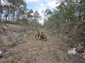
Old Hervey Bay Railway line, Queensland, Australia

Vía verde Sierra de Alcaraz
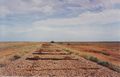
The old Ghan Railway near Maree, South Australia, Australia
Ernest junction, Molendinar, Queensland, Australia

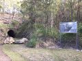
Disused railway tunnel


Rendering
Do you have some ideas?
light grey dotted line, less prominent than disused