Tag:amenity=lavoir
 |
| Description |
|---|
| A public place where people come to wash their clothes manually |
| Group: amenities |
| Used on these elements |
| Useful combination |
| Status: in use |
| Tools for this tag |
|
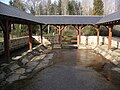
The tag amenity=lavoir is used to map a ![]() lavoir, a public feature designed for people to wash clothes manually, also known as a "wash-house" or "washing place". This name is borrowed from French where such washing places take a very particular place in local heritage. Beware : lavoir as washing places should not be mistaken with
lavoir, a public feature designed for people to wash clothes manually, also known as a "wash-house" or "washing place". This name is borrowed from French where such washing places take a very particular place in local heritage. Beware : lavoir as washing places should not be mistaken with ![]() bath and wash houses which are used for people to bath.
bath and wash houses which are used for people to bath.
In Europe they are frequently covered with a roof, they may have no or only low walls. They are frequent in rural areas next to rivers or pounds.
In urbanized regions with running water service, they have a mostly historic interest (heritage). In area where there is no running water service, such washing places may be still used. Database users should check for tags such as access=yes to confirm that the lavoir is still publically accessible, though it may not be clear whether the feature is in use.
They are of special importance in France and also in the rest of Europe, Spain and Portugal for example, where many of such antique amenities have been preserved and restored. They are also often used by walkers or cyclists to have a break, shade, shelter and fresh drinkable water.
How to map
Create a node or area and tag with amenity=lavoir to mark the location of the a lavoir.
In addition, consider adding:
- shelter=yes/no to indicate whether the lavoir is covered or not. The lavoirs are usually covered.
- water=yes/no to indicate whether there is more water flowing in the lavoir. There's still water in most lavoirs.
- access=yes/no This tag is used to indicate whether the lavoir is currently accessible to the public or not.
Many wash houses are recorded on Wikimedia (Category:Wash houses), so it might be worth checking there and adding the wikimedia_commons=* for the wash house/ lavoir.
See also
- historic=lavoir
- amenity=washing_machine
- shop=laundry
- Lavoir on wikipedia
- The proposal page
- lavoirs.org - Examples of lavoirs over the world
Other images
The Lavoir at Bonnat, France

Public wash-house Portugal (front view)

Public wash-house Portugal (rear view)

Washing place in Belgium

Historical public lavoir in Genoa, Italy

_Frente.jpg)
_Traseira.jpg)

.jpg)