Tag:barrier=kerb
| Description |
|---|
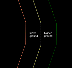
| A stone edging to a pavement or raised path (right side is bottom, left side is top). |
| Group: barriers |
| Used on these elements |
| Implies |
| Useful combination |
|
| Status: approved |
| Tools for this tag |
|
The tag barrier=kerb is used to map a kerb (US English: curb), a low raised barrier for vehicles and wheelchair users, usually found at the edge of a road, path or sidewalk. The height of the kerb is important, as with this information, it can be determined how much of an obstacle the kerb is to different users.
How to map
On a way
which gives 
|
barrier=kerb is used on a way along the length of the kerb. The lower side should be to the right of the way, the higher side to the left.
The key kerb=* can be used additionally to give a rough indication of the height or type of kerb.
To map the exact height of the kerb, on ways, most commonly height=* is used, though kerb:height=* is also sometimes seen.
On a node
Place a node on a highway, such as a highway=footway, to show the location where the highway crosses the kerb.
The kerb may be mapped separately as a barrier=kerb way. In this case, it is still advisable to put barrier=kerb on the intersection of the kerb way with the highway, to ensure that routers are aware of it.
The key kerb=* can be used additionally to give a rough indication of the height or type of kerb.
To map the exact height of the kerb, on nodes, kerb:height=* is most commonly used, though height=* is also sometimes seen.
Please do not add a barrier=kerb on a node joining the footways near the crossing (e.g. sidewalk footway joining with footway crossing the road). That would implicate that such kerbs block not only crossing the road, but also just using the sidewalk (i.e. without intending to cross the road), which is almost never the case - and which has a big implication for several classes of users (most notably, wheelchair users).
Alternative on crossings
Placing a barrier=kerb on nodes at the precise location where the footway=crossing crosses the kerb is the most detailed method of mapping kerbs, typically used in areas where sidewalks are mapped separately. A simpler alternative (especially for areas where sidewalks are not mapped separately) is to place kerb=* (without barrier=kerb) on the single highway=crossing node that is part of the road. Only one of these approaches should be used for any given crossing: if you place barrier=kerb nodes on a footway=crossing for a crossing where the highway=crossing node already has a kerb=* tag, please remove the kerb=* tag from that node (otherwise a router might think that there are four kerbs to cross).
Rendering
For ways, renderers and editors might indicate the lower side of the kerb (the right side of the OSM way) with small triangles pointing downwards.
Possible tagging mistakes
- This tag should only be placed on a node that is part of a highway when everyone travelling along the highway has to cross the kerb. For example, it should only be placed on a road (such as highway=residential) when users of the carriageway (such as cars) have to drive over the kerb at this point. If you see barrier=kerb on a road where there isn’t actually a kerb that cars have to go over, please remove it.
- For the same reason, combining with highway=crossing is usually a mistake; include kerb=* on the crossing node, but *not* barrier=kerb as there will usually not be a kerb across the major highway, though there could be a traffic_calming=table.
See also
- kerb=*


