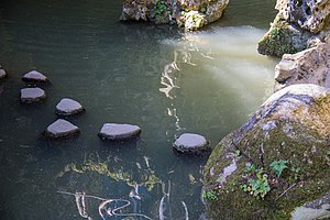
Tag:ford=stepping_stones
Jump to navigation
Jump to search
On a
On a
| Description |
|---|
| A ford for crossing a waterway with stepping stones |
| Rendering in OSM Carto |
| Group: highways |
| Used on these elements |
| Implies |
| See also |
| Status: de facto |
| Tools for this tag |
|
A ford to cross a waterway with stepping stones.
How to map
- use a single node ford where a highway crosses a waterway that is mapped as linear stream without riverbanks
- use the way-method for larger streams with mapped riverbanks
On a  node
node
The stream and highways should share a node where they cross marked with ford=stepping_stones.
On a  way
way
The highway should share nodes with the riverbanks where it crosses them and also a node with the waterway=stream where they cross. Split the highway between the riverbanks and apply ford=stepping_stones to this segment .
Example
Surface
If surface=* is untagged then it may be useful to assume surface=stepping_stones.
See also
- ford=yes
- flood_prone=* unlike fords are likely to be dangerous to cross if there is water across the roadway.


