Tag:junction=uncontrolled
 |
| Description |
|---|
| A road junction with no signs, markings, or other traffic control devices indicating junction rules. |
| Group: highways |
| Used on these elements |
| Status: in use |
| Tools for this tag |
|
An uncontrolled junction or uncontrolled intersection lacks stop signs, yield signs, stop lines, shark's teeth, traffic lights, or any other such devices to indicate junction rules.
Uncontrolled junctions are commonly found on low-traffic residential streets in the United States and Canada. In the United States and Canada, the customary rule (often recognized in law) is to treat such a junction as an all-way yield: give way to the vehicles that arrive at the intersection first, or to the vehicle on the right hand side when it is unclear who arrived first.
The purpose of this tag is to indicate that an intersection of two roads is known to be uncontrolled, rather than simply not mapped.
Usage
As a general rule, this tag should only be used at junctions of similar minor roads like highway=residential and highway=unclassified. An intersection with a highway=service and another service highway, or a road of another classification is generally not considered a junction, and should not be tagged like this.
Examples
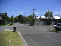
Australia:
Four-way uncontrolled intersection
United States:
An uncontrolled T-junction between two residential streets.
