Tag:railway=tram_crossing
.jpg) |
| Description |
|---|
| Pedestrians can cross a tramway here. |
| Group: railways |
| Used on these elements |
| See also |
| Status: de facto |
| Tools for this tag |
|
Tram crossing - a point where a footway crosses a tramway on the same level. Sometimes equipped with traffic signals or warning lights and/or acoustic warning.
How to map
Draw a node ![]() on the path crossing the railroad and add railway=tram_crossing.
on the path crossing the railroad and add railway=tram_crossing.
Tags to use in combination
- crossing:bell=yes/no if an acoustic warning is provided
- crossing:light=yes/no to add information about lights
- crossing:markings=* to add information about the type of markings on the ground
- crossing:signals=yes/no whether there are traffic signals for vehicles crossing the tracks
History
Editor
This has been adopted by iD in 2020 at 2.18.5 https://github.com/openstreetmap/iD/blob/release/CHANGELOG.md#2185 together with preset for railway=tram_level_crossing, now appearing alongside railway=crossing & railway=level_crossing. This was seen as controversial by some from debate in Talk:Tag:railway=tram_level_crossing, as recorded in ID/Controversial_Decisions#Tram_crossings. There are more documentation at Tag:railway=tram_level_crossing.
Note that iD pushes adding these tags at any intersection of railway=tram and road centerline, despite that due to our mapping practices it often is not representing place of a tram crossing. See examples.
Gallery


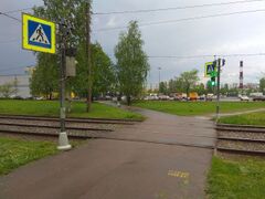
Tram crossing with traffic signals in Saint-Petersburg, Russia
.jpg)


See also
- railway=tram_level_crossing - A crossing between a tramway and a road
- highway=crossing - Pedestrians can cross a street here