Tag:tower:type=intake
.JPG) |
| Description |
|---|
| Intake Tower |
| Group: man made |
| Used on these elements |
| Useful combination |
| Status: in use |
| Tools for this tag |
|
![]()
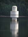
Intake Tower
In Work
Description
The intake tower is free-standing in a drinking water reservoir.
By means of inlets at different heights and pumping devices is removed, the raw water for the further treatment of drinking water here.
About pipes then the raw water reaches the ![]() Einlaufbauwerk.
Einlaufbauwerk.
The control device is located above the waterline and is often accessible via a bridge-way.
Mapping
Set a point ![]() or draw the outline
or draw the outline ![]() .
.
The bridge-way to the mainland is connected with the building.
The height is not specified here, even if it is known. A height in some maps would lead to misrepresentation.
Option. See below.
It may well be the intake towers are connected directly to the dam.
These are then to tag with building:part=yes.
- man_made=tower (obligatory)
- tower:type=intake (obligatory)
- building=yes The tower as building.
- location=underwater Describes the installation of the tower on the underwater base.
- access=private The tower and the road is private and only for staff.
- name=* name of the tower, even loc_name=* locality name
- operator=* Operator of the water intake point.
- description=* Special
Alternative altitude:
height=8 Estimated height above water level 8m ; together with
note=* a note, example "height above water 8m geschätzt, overall height 45m"
Zusatztag
thermo_proboscis=yes Thermo-Rüssel zur Entnahme von Wasser verschiedener Temperatur zur Einspeisung im Fluß zur "Fischbereicherung"
Examples
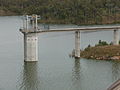
Boondooma Dam Intake Tower, Australien

Intake Tower at Talla Reservoir, Schottland

Entnahmeturm Ködeltalsperre, Deutschland
Talsperre Frauenau, Deutschland

Ronsdorfer Talsperre, Wuppertal, Deutschland

Gathright Dam Intake Tower, Virginia,USA - in der Entstehung


.jpg)


.jpg)
Siehe auch
![]() Liste von Talsperren in Deutschland
Liste von Talsperren in Deutschland
![]() Liste der Speicherseen in der Schweiz
Liste der Speicherseen in der Schweiz
![]() Liste der Stauseen in Österreich
Liste der Stauseen in Österreich
![]() Liste von Talsperren der Welt
Liste von Talsperren der Welt