Tag:wetland=marsh
Jump to navigation
Jump to search
 |
| Description |
|---|
| Marsh is periodically saturated, flooded, or ponded with water and characterized by herbaceous (non-woody) vegetation adapted to wet soil conditions. |
| Rendering in OSM Carto |

|
| Group: natural |
| Used on these elements |
| Requires |
| Status: approved |
| Tools for this tag |
|
![]() Marshes are periodically saturated, flooded, or ponded with water and characterized by herbaceous (non-woody) vegetation adapted to wet soil conditions. This tag is particularly suitable for non-tidal marshes. For tidal marshes, water is often salted and you should have a look at wetland=saltmarsh instead.
Marshes are periodically saturated, flooded, or ponded with water and characterized by herbaceous (non-woody) vegetation adapted to wet soil conditions. This tag is particularly suitable for non-tidal marshes. For tidal marshes, water is often salted and you should have a look at wetland=saltmarsh instead.
How to map
Draw the outline ![]() of the area and tag it with natural=wetland + wetland=marsh.
of the area and tag it with natural=wetland + wetland=marsh.
Rendering
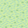
Level > 13
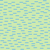
Level <=13

Similar tags
- natural=wetland + wetland=saltmarsh
- natural=wetland + wetland=wet_meadow
- natural=wetland + wetland=tidalflat