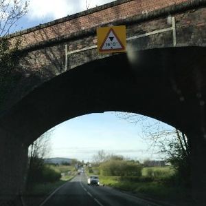
Bridge heights in the United Kingdom
(Redirected from United Kingdom bridge heights)
Jump to navigation
Jump to search

A railway bridge near Worcester as captured on OpenStreetCam (note the maxheight tag goes on the road)
Tagging bridges with the maxheight tag makes OSM a plausible option for HGV routing, so that lorries don't get stuck under low bridges
This diary entry explains a methodology for finding railway bridge heights from open street-level imagery.
If you've systematically reviewed a railway or canal for bridge heights, add it here so that others don't duplicate your work.
Open question: Should we add something like maxheight=none for situations where roads go under bridges so tall that no clearance needs to be stipulated, and also to show that such places have been surveyed and no action needs taking? Example under a viaduct. This makes the way appear green (valid) on the OSM Truck QA Map.
Railways
- Cotswold Line (Oxford-Worcester) - checked/mapped by Richard
- Malvern Line (Worcester-Hereford) - checked/mapped by Richard, some bridges around Shrub Hill station need surveying
- Penistone Line (Barnsley-Huddersfield) - checked/mapped by Paul Berry
- Arun Valley Line (Three Bridges - Arundel) - checked/mapped by Matt, Gay Street Lane bridge needs to be surveyed
- Stoke to Derby/Trent junction - checked by Richard, bridges in Stoke need survey
- West Coast Main Line (Wigan-Oxenholme) - checked/mapped by [Adam, Bridge Road in Lancaster needs to be surveyed
- Blackpool-Preston (both lines) - checked/mapped by Adam
- East Lancs line (Preston - Colne/Todmorden) checked/mapped by Adam Blackburn needs a survey
- Ribble Valley Line (Bolton-Clitheroe-Hellifield) checked/mapped by Adam Blackburn and Darwen need a survey
- Morecambe Branch checked/mapped by Adam
- North Western Railway (Carnforth- Settle Jncn) checked/mapped by Adam
- Furness Line (Carnforth-Barrow) checked/mapped by Adam Ulverston needs a survey
- Southport-Wigan-Bolton checked/mapped by Adam Foul Lane, Southport needs a survey
- Ormskirk Line (Preston-Ormskirk) checked/mapped by Adam
- Preston-Bolton checked/mapped by Adam