Pathways of desire party: Difference between revisions
mNo edit summary |
(rv removal thingmajigy) |
||
| Line 17: | Line 17: | ||
== Area == |
== Area == |
||
The general area is [http://www.openstreetmap.org/index.html?lat=51.387658428518485 |
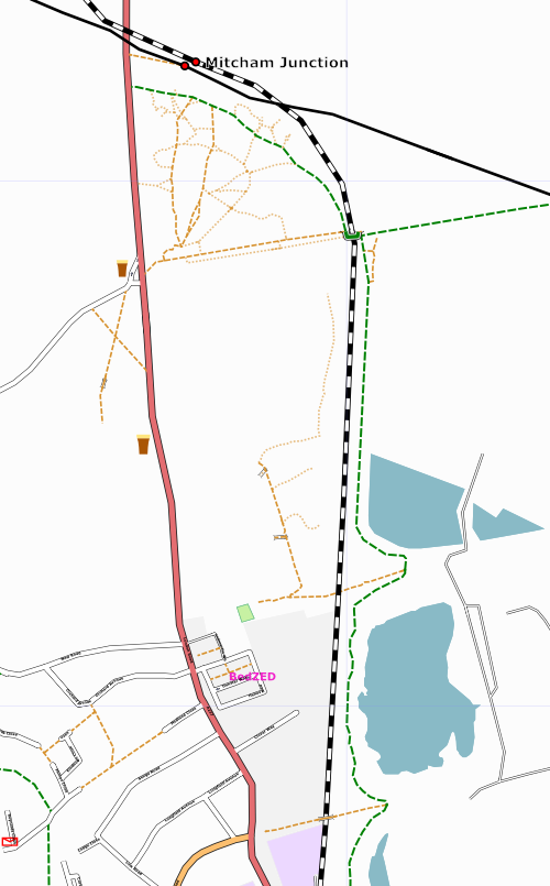
The general area is [http://www.openstreetmap.org/index.html?lat=51.387658428518485&lon=-0.15127023622767694&zoom=14 here], with BedZED sitting just to the left of the sewage works (no, those aren't circular swimming pools so don't try it!). Hackbridge station is where the southbound railway meets the primary way, and Mitcham Junction is, well, the junction! |
||
==Results== |
|||
Here are the [http://www.openstreetmap.org/traces/tag/pathwaysofdesire traces] of people mapping the pathways. |
|||
The map so far, with |
|||
* green dashed - well surfaced pathways (effectively cycleways) |
|||
* brown dashed - proper-looking pathways (effectively footpaths) |
|||
* light brown dotted - accessible pathways of desire |
|||
There is a lot of surrounding urban area to be added in by participants, and some more pathways of desire which Tom and Jess will finish off in the near future. |
|||
[[Image:pofd.png]] |
|||
==Who came== |
|||
* [[User:TomChance|TomChance]] (will drum up some press interest) |
|||
* [[User:Jessica|Jessica]] |
|||
* [[User:80n|80n]] - Saturday for sure, Sunday probably, cycling from Weybridge which will take all day anyway |
|||
* [[User:robert]] probably. |
|||
* [[User:EdD|Ed Davies]] Sunday |
|||
* [[User:Steve]] - arriving in a humvee. Hoping to join some stuff up to [[Reigate]] |
|||
* [[User:NickH]] - If I can find a spare [http://en.wikipedia.org/wiki/Mil_Mi-26 Mi-26] to sidestep those parking permits |
|||
* [[User:Gravitystorm|Gravitystorm]] - Saturday only, at the moment |
|||
* [[User:Randomjunk|Randomjunk]] - Saturday only |
|||
Revision as of 21:01, 10 April 2007
The pathways of desire party will take place on Saturday 10th and Sunday 11th March in south London. We'll meet at 11am in the BioRegional offices at BedZED (51.382175,-0.156067), where we will provide a late breakfast, tea/coffee, meeting rooms and internet connectivity. We can all pop to a pub on Saturday evening, and have lunch at BedZED. If you're lost, late or confused contact Tom (07866 447075).
Saturday will be more of a planning day, sketching out the area with main roads, etc. If you only want to come on one day, or you're new to the project, you may prefer to come on Sunday when we'll do the pathways of desire.
It's dead easy to get here by public transport, and driving here is really frowned upon, with BedZED being a sustainable development, so do come by the chuffer or pedal power. Parking permits are needed for cars so if you want to brave the wrath of Jess and Tom make sure you mention your mode of transport in the list below!
File:BIO-BEDZED-13-04-11-001254.jpg
Why on earth?
We'd like to map the pathways of desire between Hackbridge (51.37820,-0.15361) and Mitcham Junction (51.392756,-0.1569793) stations, over open land. Never mind the official classifications, where do people generally walk over this land? Some enterprising mappers can toddle around the open land mapping where people seem to walk / cycle. We intend to use the resulting maps as a basis for new cycle and footpaths linking the two stations with BedZED, the UK's largest eco-village!
The cycle and footpaths will allow staff and residents at BedZED, and of course other people living and working in this area, to get around by bike and foot without having to use the very busy and slightly dangerous London/Carshalton Road (A237). We have talked to Sustrans about this route, so hopefully the data from the mapping expedition will be a good starting point for pressing the decision makers in Sutton and Merton Borough Councils.
This area of London is really neglected, and could do with a big chunk getting mapped, so other mappers can get to work with the surrounding roads and amenities.
Area
The general area is here, with BedZED sitting just to the left of the sewage works (no, those aren't circular swimming pools so don't try it!). Hackbridge station is where the southbound railway meets the primary way, and Mitcham Junction is, well, the junction!
Results
Here are the traces of people mapping the pathways.
The map so far, with
- green dashed - well surfaced pathways (effectively cycleways)
- brown dashed - proper-looking pathways (effectively footpaths)
- light brown dotted - accessible pathways of desire
There is a lot of surrounding urban area to be added in by participants, and some more pathways of desire which Tom and Jess will finish off in the near future.
Who came
- TomChance (will drum up some press interest)
- Jessica
- 80n - Saturday for sure, Sunday probably, cycling from Weybridge which will take all day anyway
- User:robert probably.
- Ed Davies Sunday
- User:Steve - arriving in a humvee. Hoping to join some stuff up to Reigate
- User:NickH - If I can find a spare Mi-26 to sidestep those parking permits
- Gravitystorm - Saturday only, at the moment
- Randomjunk - Saturday only
