File:Crossroads with traffic islands.png
Jump to navigation
Jump to search


Size of this preview: 771 × 599 pixels. Other resolutions: 309 × 240 pixels | 618 × 480 pixels | 818 × 636 pixels.
Original file (818 × 636 pixels, file size: 797 KB, MIME type: image/png)
Summary
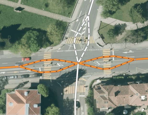
Example of a crossroads where the roads were split into two ways at traffic islands.
(Background image by courtesy of Orthophoto 2016, Vermessungsamt Stadt Bern.)
Licensing

The copyright holder of this file allows anyone to use it for any purpose, provided that the copyright holder is properly attributed. Redistribution, derivative work, commercial use, and all other use is permitted.
If you are the uploader, please provide proper attribution including source and name of author.
If you are the uploader, please provide proper attribution including source and name of author.
File history
Click on a date/time to view the file as it appeared at that time.
| Date/Time | Thumbnail | Dimensions | User | Comment | |
|---|---|---|---|---|---|
| current | 15:21, 26 November 2017 | | 818 × 636 (797 KB) | SelfishSeahorse (talk | contribs) | Example of a crossroads where the roads were split into two ways at traffic islands. (Background image by courtesy of Orthophoto 2016, Vermessungsamt Stadt Bern.) |
You cannot overwrite this file.
File usage
There are no pages that use this file.