File:Density of rural facilities in India.jpeg
Jump to navigation
Jump to search

Size of this preview: 600 × 600 pixels. Other resolutions: 240 × 240 pixels | 480 × 480 pixels | 972 × 972 pixels.
Original file (972 × 972 pixels, file size: 261 KB, MIME type: image/jpeg)
Summary
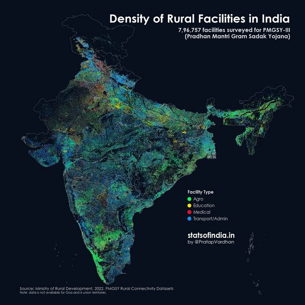
Visualization of the India/PMGSY_rural_connectivty_data_import rural POI data
Source: Pratap Vardhan https://twitter.com/Stats_of_India/status/1496117483161657349
Licensing
![]()
![]()
![]()
This work is licensed under the Creative Commons Attribution-ShareAlike 4.0 License.
Attribution not specified as a parameter! THIS LICENSE ALWAYS REQUIRES ATTRIBUTION! Use {{CC-BY-SA-4.0|Attribution, typically name of author}} See Template:CC-BY-SA-4.0 for full description this template should be used.
Attribution not specified as a parameter! THIS LICENSE ALWAYS REQUIRES ATTRIBUTION! Use {{CC-BY-SA-4.0|Attribution, typically name of author}} See Template:CC-BY-SA-4.0 for full description this template should be used.
File history
Click on a date/time to view the file as it appeared at that time.
| Date/Time | Thumbnail | Dimensions | User | Comment | |
|---|---|---|---|---|---|
| current | 06:06, 26 February 2022 | | 972 × 972 (261 KB) | Planemad (talk | contribs) | Visualization of the India/PMGSY_rural_connectivty_data_import rural POI data Source: Pratap Vardhan https://twitter.com/Stats_of_India/status/1496117483161657349 |
You cannot overwrite this file.
File usage
The following page uses this file: