File:Dry stone wall Malham 05.JPG
Jump to navigation
Jump to search


Size of this preview: 800 × 600 pixels. Other resolutions: 320 × 240 pixels | 640 × 480 pixels | 1,024 × 768 pixels | 1,280 × 960 pixels | 2,560 × 1,920 pixels.
Original file (2,560 × 1,920 pixels, file size: 1.19 MB, MIME type: image/jpeg)
This file and its description are from Wikimedia Commons.
Summary
| Description | |
| Date | 5 August 2006 (according to Exif data) |
| Source | Own work |
| Author | Immanuel Giel |
Licensing
| I, the copyright holder of this work, release this work into the public domain. This applies worldwide. In some countries this may not be legally possible; if so: I grant anyone the right to use this work for any purpose, without any conditions, unless such conditions are required by law. |
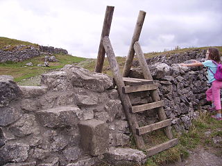
Il s'agit d'un échalier, double en l'occurrence : d'une part en pierre, d'autre part en bois. L'échalier en pierres (à gauche) a été maçonné avec du mortier pour que les pierres saillantes ne basculent pas sous le poids de l'escaladeur. L'échelle en bois (à droite) a été rajoutée car l'ancien système n'est guère pratique si l'on n'a pas un bâton sur lequel prendre appui.
File history
Click on a date/time to view the file as it appeared at that time.
| Date/Time | Thumbnail | Dimensions | User | Comment | |
|---|---|---|---|---|---|
| current | 13:56, 28 August 2006 | | 2,560 × 1,920 (1.19 MB) | wikimediacommons>Immanuel Giel | '''Description''': Dry stone wall in North Yorkshire, United Kingdom <br> '''Source''' own photography --~~~~ {{PD-self}} Category:Dry stone walls Category:Yorkshire Dales |
File usage
The following page uses this file: