File:Lebap district changes.jpg
Jump to navigation
Jump to search


No higher resolution available.
Lebap_district_changes.jpg (800 × 573 pixels, file size: 244 KB, MIME type: image/jpeg)
Summary
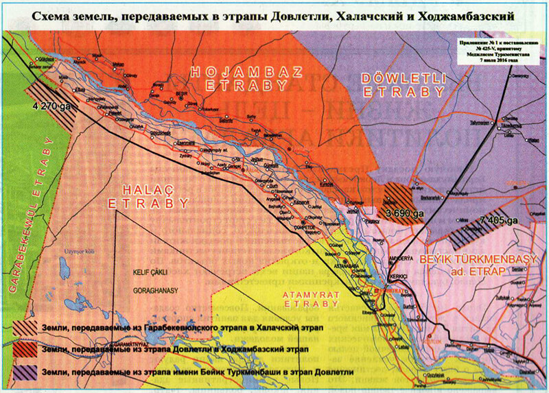
| Description | Map showing results of Turkmen Parliamentary Resolution No. 425-V of 27 July 2016, changing boundaries of districts in Lebap province. Published in the official gazette of the government of Turkmenistan. |
|---|---|
| Author | Turkmenistan Parliament |
| Source | Official gazette of the government of Turkmenistan, Resolution No. 425-V of 27 July 2016 |
| Date | 2016-07-27 |
Licensing
This document is in the public domain.
Under Turkmenistan's copyright law,
Article 7. Works that are not objects of copyright
Not subject to copyright:
- official documents (laws, court decisions, other texts of a legislative, administrative and judicial nature), as well as their official translations;
- state symbols and signs (flag, coat of arms, anthem, awards, banknotes and other state symbols and signs);
- folk art (expressions of folklore); - messages about events and facts of an informational nature.''
File history
Click on a date/time to view the file as it appeared at that time.
| Date/Time | Thumbnail | Dimensions | User | Comment | |
|---|---|---|---|---|---|
| current | 00:23, 18 January 2020 | | 800 × 573 (244 KB) | Apm-wa (talk | contribs) | Map showing results of Turkmen Parliamentary Resolution No. 425-V of 27 July 2016, changing boundaries of districts in Lebap province. Published in the official gazette of the government of Turkmenistan. |
You cannot overwrite this file.
File usage
There are no pages that use this file.