File:OSMecum-santé.pdf
Jump to navigation
Jump to search
 Size of this JPG preview of this PDF file: 800 × 566 pixels. Other resolutions: 320 × 226 pixels | 640 × 453 pixels | 1,024 × 724 pixels | 1,280 × 905 pixels | 1,752 × 1,239 pixels. |
Original file (1,752 × 1,239 pixels, file size: 706 KB, MIME type: application/pdf, 2 pages)
Summary
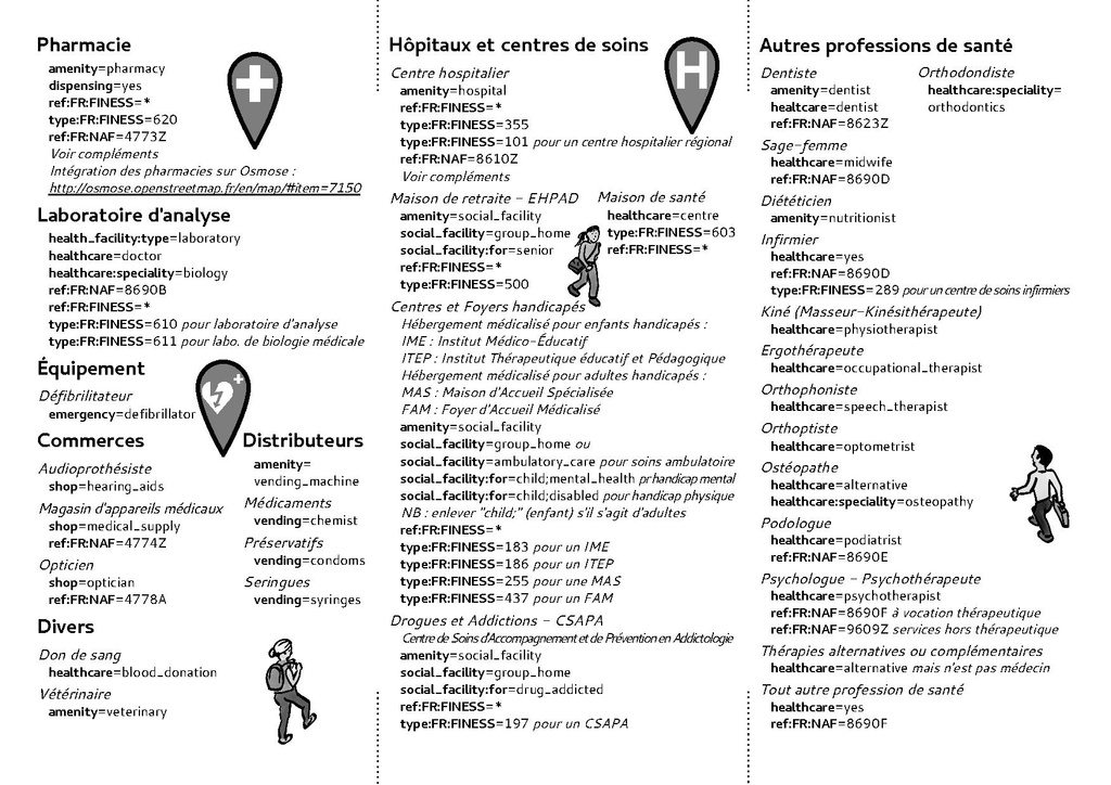
Osmecum : Comment cartographier les services de santé ?
- Financement : Fondation AFNIC
- Conception : Jean-Christophe Becquet / Guillaume Doukhan / Camille Bissuel
- Illustrations et mise en page : Nylnook pour l'ADRETS et Apitux, licence Creative Commons by-sa 4.0 2017
Sources au format Scribus 1.4.6
Licensing
![]()
![]()
![]()
This work is licensed under the Creative Commons Attribution-ShareAlike 4.0 License.
Attribution not specified as a parameter! THIS LICENSE ALWAYS REQUIRES ATTRIBUTION! Use {{CC-BY-SA-4.0|Attribution, typically name of author}} See Template:CC-BY-SA-4.0 for full description this template should be used.
Attribution not specified as a parameter! THIS LICENSE ALWAYS REQUIRES ATTRIBUTION! Use {{CC-BY-SA-4.0|Attribution, typically name of author}} See Template:CC-BY-SA-4.0 for full description this template should be used.
File history
Click on a date/time to view the file as it appeared at that time.
| Date/Time | Thumbnail | Dimensions | User | Comment | |
|---|---|---|---|---|---|
| current | 07:32, 5 December 2017 |  | 1,752 × 1,239, 2 pages (706 KB) | Apitux (talk | contribs) | Osmecum Santé : Comment cartographier les services de santé ? |
You cannot overwrite this file.
File usage
The following 3 pages use this file: