File:Roosevelt Glacier 6940.JPG
Jump to navigation
Jump to search


Size of this preview: 800 × 600 pixels. Other resolutions: 320 × 240 pixels | 640 × 480 pixels | 1,024 × 768 pixels | 1,280 × 960 pixels | 1,600 × 1,200 pixels.
Original file (1,600 × 1,200 pixels, file size: 666 KB, MIME type: image/jpeg)
This file and its description are from Wikimedia Commons.
Summary
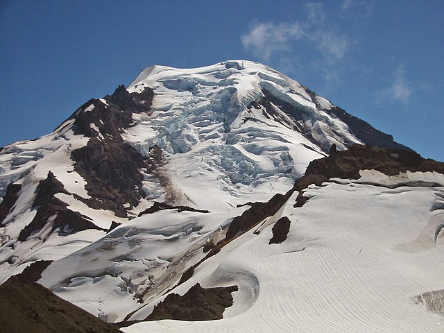
Mount Baker
| Description |
English: Roosevelt Glacier on the north face of Mount Baker. The ice cliff to the left of the ice fall and above the debris covering the glacier is 70 to 140 feet high. In the foreground, the small Bastile Glacier (lower right) covers the north face of point 7842 feet, the summit of Bastile Ridge. At its upper edge is an excellent example of a bergshrund, a crevasse that forms at the boundary between the stationary ice attached to the headwall and the glacier ice flowing downward. |
| Date | 17 August 2003, 14:02:15 −07:00 |
| Source | Own work |
| Author | Walter Siegmund |
| Camera location | | View this and other nearby images on: OpenStreetMap |
|---|
- Location Datum: WGS84/NAD83
- Viewpoint location: Northwest ridge of Hadley Peak, Mount Baker Wilderness
- Viewpoint elevation: 7150 foot (2179 m)
- View direction: South
- Camera: Canon PowerShot S110
- Exposure Time: 1/1000
- F Number: f/10.0
- Focal Length: 10.8
- Focal Length In 35mm Film:
- Flash: No
- ISO Speed Rating:
©2006 Walter Siegmund
Licensing
I, the copyright holder of this work, hereby publish it under the following licenses:

|
Permission is granted to copy, distribute and/or modify this document under the terms of the GNU Free Documentation License, Version 1.2 or any later version published by the Free Software Foundation; with no Invariant Sections, no Front-Cover Texts, and no Back-Cover Texts. A copy of the license is included in the section entitled GNU Free Documentation License. |
| This file is licensed under the Creative Commons Attribution-Share Alike 3.0 Unported license. | ||
| ||
| This licensing tag was added to this file as part of the GFDL licensing update. |
This file is licensed under the Creative Commons Attribution 2.5 Generic license.
- You are free:
- to share – to copy, distribute and transmit the work
- to remix – to adapt the work
- Under the following conditions:
- attribution – You must give appropriate credit, provide a link to the license, and indicate if changes were made. You may do so in any reasonable manner, but not in any way that suggests the licensor endorses you or your use.
You may select the license of your choice.
File history
Click on a date/time to view the file as it appeared at that time.
| Date/Time | Thumbnail | Dimensions | User | Comment | |
|---|---|---|---|---|---|
| current | 23:05, 6 February 2012 | | 1,600 × 1,200 (666 KB) | wikimediacommons>Wsiegmund | Photoshop Elements 4.0; 30% Auto Smart Fix, Adjust Lighting/Shadows/Highlights, Levels tools |
File usage
The following page uses this file: