File:Screenshot from Microsoft Libya damage visualiser 2023-09-18.png
Jump to navigation
Jump to search

Size of this preview: 800 × 377 pixels. Other resolutions: 320 × 151 pixels | 640 × 301 pixels | 1,024 × 482 pixels | 1,912 × 900 pixels.
Original file (1,912 × 900 pixels, file size: 3.14 MB, MIME type: image/png)
Summary
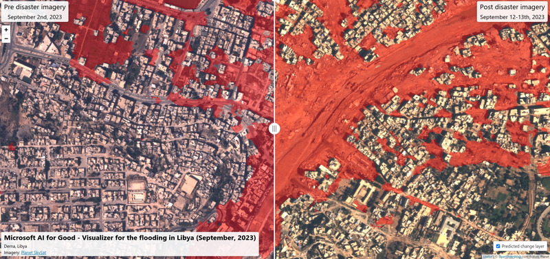
| Description | Screenshot_from Microsoft Libya damage visualiser |
|---|---|
| Author | |
| Source | https://satelliteimagerydemostg.z5.web.core.windows.net/damage-assessment/libya_derna_flooding_9_12_2023.html |
| Date | 18 Sept |
Licensing

The copyright holder of this file allows anyone to use it for any purpose, provided that the copyright holder is properly attributed. Redistribution, derivative work, commercial use, and all other use is permitted.
If you are the uploader, please provide proper attribution including source and name of author.
If you are the uploader, please provide proper attribution including source and name of author.
File history
Click on a date/time to view the file as it appeared at that time.
| Date/Time | Thumbnail | Dimensions | User | Comment | |
|---|---|---|---|---|---|
| current | 08:33, 18 September 2023 | | 1,912 × 900 (3.14 MB) | Pedrito1414 (talk | contribs) | {{Information | description=Screenshot_from Microsoft Libya damage visualiser | source=https://satelliteimagerydemostg.z5.web.core.windows.net/damage-assessment/libya_derna_flooding_9_12_2023.html | date=18 Sept | author= | other_versions= }} |
You cannot overwrite this file.
File usage
There are no pages that use this file.