Cēsis/Mapping party 2010.07.10
A mapping party is planned for Cēsis.
The plan
On Saturday, it is planned to start at 10:00.
Meeting at Cēsu castle/museum: http://osm.org/go/0wPqhZMr-?m .
Who's coming
 Pecisk (on osm, edits, contrib, heatmap, chngset com.)
- richlv (on osm, edits, contrib, heatmap, chngset com.)
- Karlis (on osm, edits, contrib, heatmap, chngset com.)
- extropy (on osm, edits, contrib, heatmap, chngset com.)
- cuu508 (on osm, edits, contrib, heatmap, chngset com.)
- Janis (on osm, edits, contrib, heatmap, chngset com.)
- Jancis (on osm, edits, contrib, heatmap, chngset com.)
- Ilga (on osm, edits, contrib, heatmap, chngset com.)
Results
This mapping party one month ago can be announced a huge success. There were approximately 11.5 participants, which alone is wonderful. In addition to that, these participants managed to significantly improve the Cēsis map.
Party render
Of course, significant part of that was done by survey on the ground - so here's the shiny part, party render image (click on the image for full size).

Party render video
Additionally, a video, showing movement of all participants is available. At first you can see how most people arrive. then there's a pause while everybody gathers and regions are dealt out. Then everybody heads out to their assigned region. After a while everybody returns, but after general meeting there's still somebody having additional surveying done.
Please note that colours in the image and video are different.
Before/after
Then a question might arise - was anything mapped as well? As usual, mapping after the party takes some time. Here is an animation showing the change between June 22nd (that's a couple of weeks before the actual party) and August 12th - slightly more than a month inbetween.

As a result, uncompressed OSM data file for Cēsis has grown from ~508 KB to ~ 6.57 MB - more than 13 times.
Thanks to all the participants, and let's meet in another mapping party.
Gallery
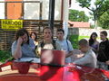
Planning the party.
Still planning the party.
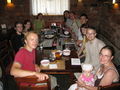
Some come-together after the survey - 11.5 participants.
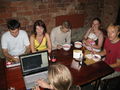
Trace exchange & collecting, as well as some JOSM work already being done.


