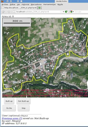
EC-JRC built-up areas from Bing
This is partially a follow-up to this thread: https://lists.openstreetmap.org/pipermail/imports/2011-June/000987.html
We (the Joint Research Centre of the European Commission) have developed a set of algorithms to extract built-up areas, built-up density, and location of human settlements from (very) high resolution satellite imagery. The result is quite reliable and our methodology has been warmly recieved by the remote sensing community. The methodology is described in this paper: http://ieeexplore.ieee.org/search/srchabstract.jsp?tp=&arnumber=5764726
We would like to run our script on Bing data and work with other OSM contributors to do some validation and quality control of the results, before putting the validated result in OSM. We have built the technical capacity to run it on a global scale on (very) high resolution satellite imagery. We would like to discuss the best way to do so, and plan to start with our local area (West of Milano), of course after further discussion with the local community and avoiding duplication of existing OSM data.
The above is just a very preliminary discussion of what we suggest to do.
https://lists.openstreetmap.org/pipermail/imports/2011-July/000995.html
Previous discussion
Note: this was discussed on the import mailing list and discusses ideas that were abandoned. In particular, we gave up the idea of an import. It is kept here for reference.
Frederik Ramm noted rightfully that: "The only thing that is really widely used in OSM is landuse=residential". Mayeul Kauffmann answered: "Agreed on the usefulness and frequency of the tag landuse=residential. However, I'd like to mention that OSM lacks a more general tag for saying “built-up area” (which may be something like landuse=residential + landuse=commercial + landuse=retail and maybe a few more). There is a huge grey zone between the above categories as you often find a mix of these in the same street and even in the same building (ground floor as shop, other floors as residential). "Built-up" is very easy to agree on. (Easier than the dominant use of building in an area)."
On openstreetmap, there are several tags that are related to our understanding of density of building layer. Some of them are: density= (with categories or percentage) building:density:grade = (with numerical category)
In the wiki there is a proposal for tagging settlements in a 0-30 scale (rank) according to importance. There are also many qualitative tags for different types of human settlements in OSM: place= (categories based on size and density of human settlements). We could build on those with some additional data or create similar tags to upload polygons to openstreetmap. Some links below:
Example with "building:density:grade = ": https://www.openstreetmap.org/browse/relation/1285833
Example combination of tags: https://www.openstreetmap.org/browse/way/6335462
Other related tags:
https://taginfo.openstreetmap.org/keys/density#values https://wiki.openstreetmap.org/wiki/Proposed_features/new_place_values#Introducing_rank_as_an_additional_key_to_define_a_finer_grained_structure https://wiki.openstreetmap.org/wiki/Proposed_features/new_place_values https://wiki.openstreetmap.org/wiki/Buildings https://wiki.openstreetmap.org/wiki/Tag:place%3Disolated_dwelling https://wiki.openstreetmap.org/wiki/Tag:place%3Dhamlet https://wiki.openstreetmap.org/wiki/Tag:place%3Dvillage https://wiki.openstreetmap.org/wiki/Tag:place%3Dcity https://wiki.openstreetmap.org/wiki/Tag:place%3Dtown https://wiki.openstreetmap.org/wiki/Key:place https://wiki.openstreetmap.org/wiki/Proposed_features/centre_zone https://wiki.openstreetmap.org/wiki/Tag:landuse%3Dresidential
