FR:2014 West Africa Ebola Response
| General Information | |
| Réponse à l'Ebola en Afrique de l'Ouest 2014 est une activation de la Humanitarian OSM Team pour fournir des données cartographiques pour assister la réponse face à l'éruption de cette maladie. Le 23 mars 2014 - Les membres individuels du HOT commencent surveiller les nouvelles concerntant l'éruption d'Ebola en Afrique de l'Ouest. C'est le 24 mars que notre organisation recevait une demande d'assister Médecins Sans Frontières.
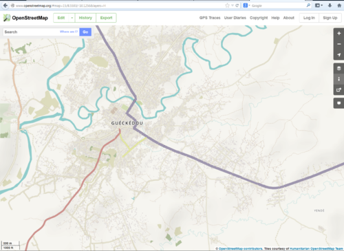
CartONG fournit MSF Suisse pour l'épidémie d'Ebola en fournissant un soutien au SIG afin d'entrer en Guinée. Il y a un du personnel déployé en Guinée. Les images Bing ne sont pas disponibles dans zones varieuses où on rapporte des cas suspectés d'Ebola. Pour ces zones, les CartONG achetait des images Pleiades-1A. Le Groupe humanitaire OpenStreetMap a été activé pour coordonner l'effort cartographique des contributeurs d'OSM. D'autres groupes comme VISOV collaborent également dans cette activation.  Carte montre la zone autour de Gueckedou en OSM 28 mars 2014 | |
Services des cartes et données
Sur OpenStreetMap
OpenStreetMap offers an online map that is updated by the minute. Various tools and services allow data extracts for GIS specialists, Routable Garmin GPS data, OSMAND, and other device-compatible downloads. With an Internet connection, it is possible to sync regularly with data contributed by the OSM community as it comes in. Bulk downloads of OpenStreetMap data are ideal for use offline. In addition, maps also can be printed to paper.
Browse the map to get a feel for the data we have available. Different map styles can be selected on the right side.
See Downloading data for instructions on getting large downloads of map data. See Shapefiles if you need this format.
Cartes sur papier
- Raw OSM extracts for GIS Analysis : {source to provide}
- Garmin Routable GPS Map : {source to provide}
- Navigation Offline Data for Android smartphones : {source to provide}
(install by copying to OsmAnd directory on your Android device). With limited communications in a disaster region, it is recommended to download offline data before travelling to this region. - Paper Maps Poster size can be printed
- FieldPapers Paper Maps with grid for field survey,
- MapOSMatic Large Paper Maps with grid, street index and POI and
Utilisation des données d'OSM pour les missions humanitaires
- Add links/stories of usage here...
Information sur cette activation humanitaire
Sur HOT
- To learn more about the Humanitarian OpenStreetMap Team (HOT), explore more of our wiki-pages (root: HOT) or our web site hotosm.org. We are a global community of mostly volunteers. We are also a U.S. nonprofit able to contract with organizations (email info at hotosm.org to contact our staff) Further, we are a 501 C-3 charitable organization.
Actualités HOT
- HOT Coordinator(s) requesting remote mapping assistance March 24 to present (un-estimated duration)
Histoire de cette activation
Reactivity of the OSM Community
- March 23 - HOT Members begin monitoring news reports about the outbreak and informing community.
- March 24 - We receive a request for activation from CartONG and MSF-CH
HOT Activates
- March 24 - We begin trying to locate imagery for the 3 main towns (Guekedou, Kissigoudou, and Macenta)
- March 25 - We have multiple versions of the Landsat 8 tile covering the area online in several different color bands
- March 25 - We begin using the Landsat imagery to trace roads and village perimeters
- March 25 - We also do the same from some Orbview 3 image strips across the area
- March 26 - Reception of high resolution imagery for the 3 main towns, creation of task manager jobs and appeal to contributors to map.
- March 26 - Cumulative statistisc : 136 contributors, 270,000 changes
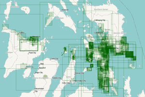
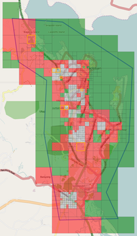
- March 27 - Adding more areas of interest as Tasking Manager Jobs, see below.
Outils, adaptation et services
The various OSM developers communicate over the Internet through various communication channels. In 2013 they implemented the new Humanitarian Map Style, a map more adapted to humanitarian actions. This map, hosted by OpenStreetMap - France, is integrated in various online map tools.
The Tasking Manager and the JOSM editor are essential parts of this activation. As new imagery is available, new jobs are added to the Tasking Manager. It has allowed HOT to coordinate efforts of mappers around the world. Some days there were more then 200 simultaneous mappers registered on the Task Manager and editing mainly with the JOSM editor. Online editors also are used for less-intensive mapping. LearnOSM.org offers learning material for beginners and more advanced mappers.
Coordination
Andrew Buck and Pierre Beland, assisted by Amadou Ndong are coordinating this activation. The request for Activation first came from Médecins Sans Frontières / Doctors Without Borders. We coordinate with our partners and the Digital Humanitarian Network. Regions requiring mapping are coordinated through the use of the HOT Tasking Manager.
Équipe de support
User:russdeffner is currently helping the coordination by creating and updating this wiki-page on behalf of the coordinator team. Further details to come...
Efforts connus
Further details to come...
Comment vous pouvez contribuer
Apprenez à cortographier
- Most of our volunteer needs are for remote OSM contributors, visit LearnOSM.org to get started.
- Read guidelines on how to tag roads in Africa.
Priorités cartographiques
- Veuillez choisir en premier les priorités très importantes
| Tâche | Priorité | Endroit | Que faire sur la carte | Source des images | État de tâche cartographique | État de tâche de validation |
|---|---|---|---|---|---|---|
| Job 463 | Low | Guinée | roads and residential | Landsat-8 | In Progress | In Progress |
| Job 465 | Medium | Guinée | roads and residential | OrbView-3 | In Progress | In Progress |
| Job 469 | Guekedou | roads and buildings | Pleiades-1A, CNES, Astrium | Complete | Complete | |
| Job 470 | High | Kissigoudou | roads and buildings | Pleiades-1A, CNES, Astrium | Complete | In Progress |
| Job 471 | Macenta | roads and buildings | Pleiades-1A, CNES, Astrium | Complete | Complete | |
| Job 472 | Medium | Kankan | roads and buildings | Bing | In Progress | In Progress |
| Job 473 | High | N'zérékoré | roads and buildings | Bing | In Progress | In Progress |
| Job 475 (dev server) |
Medium | Population | buildings and huts | Bing | (ongoing - more tiles to be added) |
(ongoing - more tiles to be added) |
| Job 475 | Medium | Conakry | roads and landuse | Bing | In Progress | In Progress |
Beyond these, we need experienced mappers to make assessments of missing data on a wider scale. Fix-up of place names is needed. There are several old topographic maps of this area with many place names listed on them and possibly alternate spellings as well.
Cartes de réponse
- Add links/examples of response maps for the area, here...
Images disponibles
The Bing imagery coverage in this part of Africa is pretty low-resolution. All the key towns and much of the wider area have no Bing coverage. The group CartoNG has purchased imagery on behalf of MSF-Switzerland for the three largest towns in the region. Task manager jobs have been created for these towns, and these are currently our number one priority. Our secondary priority is to trace roads and locations of villages in the wider region from a Landsat 8 images taken the 23rd of March. We also have some scattered Orbview 3 images (from around 1990) for a very limited region. Everything that can be mapped from these images is being mapped, but these are a lower priority than the main cities.
Comment ajouter à OSM
It's easy to add special imagery to JOSM from the Task Manager jobs, where an imagery URL is provided within the Task Manager. Clicking the URL should trigger JOSM remote control to add the new imagery as a layer. For more details see OSM Tasking Manager/Setting up JOSM
Bing
Bing is the 'default' Imagery available for OSM (default option in most editors). However, as we said, the Bing imagery in this part of Africa is low-resolution. The key towns and much of the wider area have no Bing coverage.
(Autres sources des images)
- Add sources and relevant information on imagery (broken into source) here...
Potential Datasources
Add potential data sources here...
Cartes historiques
- Provide links to historical maps of the impacted area here...
- Historical maps, and other out-of-copyright sources can be rectified and used as a layer through MapWarper
Événements Mapathon
- OSM-Colorado HOT Saturday Mapternoon on Mumble
- Add your event here...
Événements passés
- Add past mapping events/projects in the impacted area here...
Contributor Statistics for this Activation
- Add links to contributor stats for this activation here...
Media coverage
En allemand
En anglais
- Crowdsourced tracing effort launched for mapping Ebola virus outbreak in Guinea, Geospatial World, Mar.26
- Mapping Guinea: Help Wanted for Ebola Outbreak, GIS News, Mar.26
En français
- Epidémie d'Ebola en Guinée: MSF envoie en urgence des spécialistes et du matériel, MSF-CH, Mar.22
- Digitalisation d'urgence en Guinée contre l'épidémie Ebola !, CartONG, Mar.26
Autres réponses dont Digital Humanitarian Network
- Provide links to other relevant responses here...
- Officier SIG MSF-CH déployé en Guinée Conakry - 18 Avril 2014 : "Aux équipes/ communautés OSM et HOT, Avant toute chose et une fois de plus, nous voudrions vous transmettre nos vifs remerciements à chaque individu actif dans cette réponse de crise. Votre travail est un don pour celles et ceux engagés dans la réponse sur le terrain. Votre cartographie à l'échelle du bâti sur de si larges théâtres d'opération est une aide immense et précieuse pour nos équipes mobiles, ainsi que pour les nombreux internationaux récemment arrivés et nécessitant un briefing sur la dynamique notamment spatiale de l'épidémie. Identifier, localiser et accéder à des lieux de peuplement reculés est très souvent une course contre le temps dès lors que quelques heures peuvent faire la différence et pour les patients, et pour arriver à temps de façon à prévenir de nouvelles contaminations et d'enrayer ainsi la propagation de l'épidémie. L'utilisation conjointe des savoirs de terrain mobilisables et des cartes OSM ou produites à partir de données OSM nous a permis de gagner en efficacité, d'améliorer par des gains de temps l'élasticité de notre réponse.
- Officier SIG MSF-CH déployé en Guinée Conakry - 2 Avril 2014 : "Un profond merci de la part de l'équipe d'urgen de Gueckedou et Macenta pour toutes celles et ceux d'OSM et HOT actifs dans cette réponse ! Votre travail par sa rapidité d'execution et sa qualité est très au-delà de nos attentes initiales. Les jeux de cartes faits de vos données, sitôt partagés avec nos équipes de terrain, ont reçu un accueil enthousisaste aussi de la part des internationaux que des nationaux. Dans ce moment de lutte contre la propagation de l'épidémie, le fait de sentir votre présence et d'éprouver et bénéficier de ce soutien de la communauté globale des cartographes fait vraiment chaud au coeur. "
Autres liens
- Ebola
- Fournir des liens pertinents ici ...

