File:Autorizacao SBC.pdf
 Size of this JPG preview of this PDF file: 463 × 599 pixels. Other resolutions: 185 × 240 pixels | 371 × 480 pixels | 593 × 768 pixels | 1,275 × 1,650 pixels. |
Original file (1,275 × 1,650 pixels, file size: 312 KB, MIME type: application/pdf, 2 pages)
Summary
| Description | Capture of the e-mail sent by the Municipality of São Bernardo do Campo (SBC), where the use of their data is authorized on OpenStreetMap. |
|---|---|
| Author | matheusgomesms |
| Source | Own |
| Date | 2023-09-14 |
English
Message Transcript and translated:
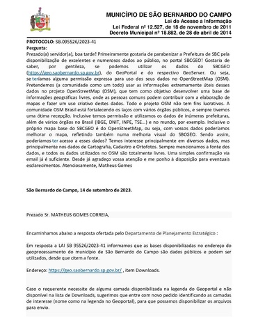
PROTOCOL: SB.095526/2023-41
Question:
Dear Civil Servant, good afternoon!
Firstly, I would like to congratulate Municipality of SBC for making excellent and numerous data available to the public on the SBCGEO portal!
I would like to know, please, if we can use data from SBCGEO (https://geo.saobernardo.sp.gov.br), GeoPortal and the respective GeoServer. I.e, whether we would have any express permission to use your data in OpenStreetMap (OSM).
We (the community as a whole) intend to use the extremely useful information from these data in the OpenStreetMap (OSM) project, which aims to develop a free geographic information base, where ordinary people can contribute to the creation of maps and make creative use of these data. The entire OSM project is non-profit.
The OSM Brazil community is strengthening ties with various public bodies, and we have always had a great reception. We even have permission and use data from numerous city halls, as well as various bodies in Brazil (IBGE, DNIT, INPE, TSE...) and around the world, for example. Even the SBCGEO base map itself is from OpenStreetMap, that is, with your data we could improve the map, also reflecting a visual improvement of SBCGEO.
So, could we have access to this data? We are mainly interested in various data, but mainly in Cartography, Cadastre and Orthophotos data.
We always mention the source of the data, and all data used in OSM is completely free. A simple confirmation via email is enough.
Thank you in advance for your attention and I remain at your disposal for any clarifications.
Yours sincerely,
Matheus Gomes
Response from City Hall
São Bernardo do Campo, September 14, 2023.
Dear Mr.,
We forward the response offered by the Strategic Planning Department below:
In response to Protocol SB 95526/2023-41, we inform that the databases made available at the geoprocessing address in the municipality of São Bernardo do Campo are public data and can be used, as long as the source is cited.
Address: https://geo.saobernardo.sp.gov.br/, item Downloads.
If the applicant needs a layer available in the Geoportal caption and not available in the Downloads list, we suggest that they submit a new request identifying the layers of interest (name as in the Geoportal caption), so that we can make the files available for sending.
We also inform you that Orthophotos are heavy files, which makes it difficult to send this layer. If necessary, we can check other means to make the download of a lighter file of this layer available.
It would be necessary to create an access link through the DTI to enable the files to be downloaded.
Yours sincerely,
ADMINISTRATION AND INNOVATION SECRETARIAT
SA-101 - REQUEST AND INFORMATION PROCESSING SECTION
Português
Captura da mensagem de e-mail emitido pela Prefeitura de São Bernardo do Campo, onde se autoriza o uso dos seus dados no OpenStreetMap.
Transcrição da mensagem:
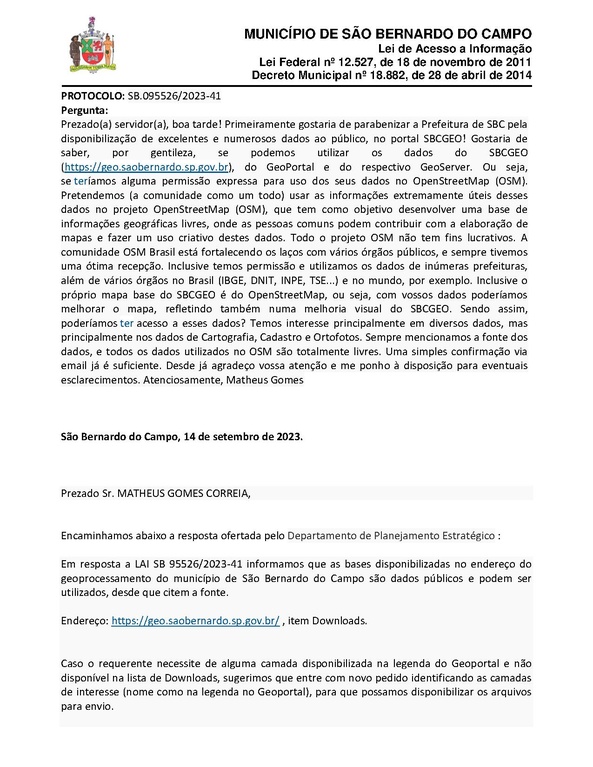
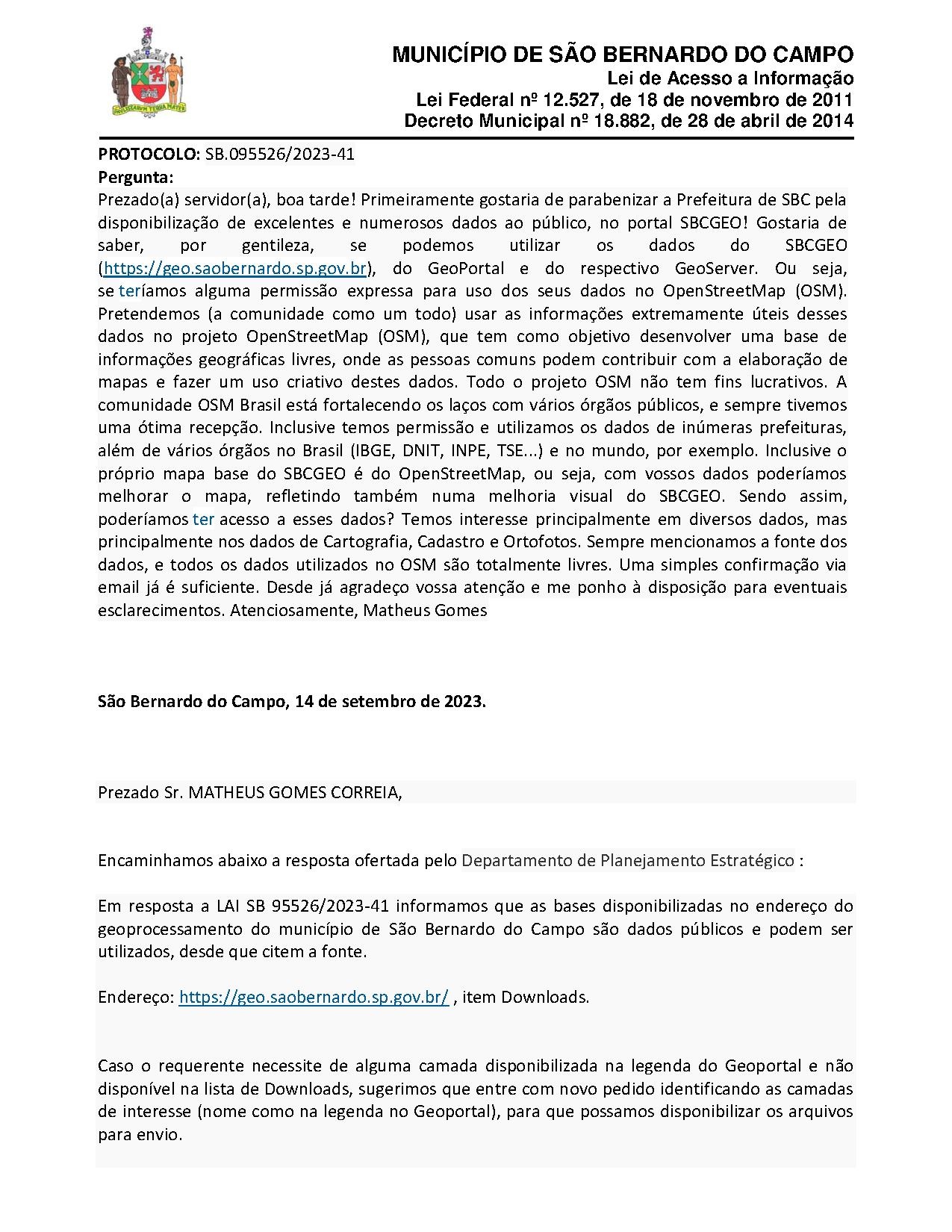
PROTOCOLO: SB.095526/2023-41
Pergunta:
Prezado(a) servidor(a), boa tarde!
Primeiramente gostaria de parabenizar a Prefeitura de SBC pela disponibilização de excelentes e numerosos dados ao público, no portal SBCGEO!
Gostaria de saber, por gentileza, se podemos utilizar os dados do SBCGEO (https://geo.saobernardo.sp.gov.br), do GeoPortal e do respectivo GeoServer. Ou seja, se teríamos alguma permissão expressa para uso dos seus dados no OpenStreetMap (OSM).
Pretendemos (a comunidade como um todo) usar as informações extremamente úteis desses dados no projeto OpenStreetMap (OSM), que tem como objetivo desenvolver uma base de informações geográficas livres, onde as pessoas comuns podem contribuir com a elaboração de mapas e fazer um uso criativo destes dados. Todo o projeto OSM não tem fins lucrativos.
A comunidade OSM Brasil está fortalecendo os laços com vários órgãos públicos, e sempre tivemos uma ótima recepção. Inclusive temos permissão e utilizamos os dados de inúmeras prefeituras, além de vários órgãos no Brasil (IBGE, DNIT, INPE, TSE...) e no mundo, por exemplo. Inclusive o próprio mapa base do SBCGEO é do OpenStreetMap, ou seja, com vossos dados poderíamos melhorar o mapa, refletindo também numa melhoria visual do SBCGEO.
Sendo assim, poderíamos ter acesso a esses dados? Temos interesse principalmente em diversos dados, mas principalmente nos dados de Cartografia, Cadastro e Ortofotos.
Sempre mencionamos a fonte dos dados, e todos os dados utilizados no OSM são totalmente livres. Uma simples confirmação via email já é suficiente.
Desde já agradeço vossa atenção e me ponho à disposição para eventuais esclarecimentos.
Atenciosamente,
Matheus Gomes
Resposta da Prefeitura
São Bernardo do Campo, 14 de setembro de 2023.
Prezado Sr.,
Encaminhamos abaixo a resposta ofertada pelo Departamento de Planejamento Estratégico:
Em resposta a LAI SB 95526/2023-41 informamos que as bases disponibilizadas no endereço do geoprocessamento do município de São Bernardo do Campo são dados públicos e podem ser utilizados, desde que citem a fonte.
Endereço: https://geo.saobernardo.sp.gov.br/ , item Downloads.
Caso o requerente necessite de alguma camada disponibilizada na legenda do Geoportal e não disponível na lista de Downloads, sugerimos que entre com novo pedido identificando as camadas de interesse (nome como na legenda no Geoportal), para que possamos disponibilizar os arquivos para envio.
Informamos também que as Ortofotos são arquivos pesados, o que dificulta o envio desta camada, caso seja necessário, podemos verificar outros meios para disponibilizar o download de um arquivo mais leve desta camada.
Seria necessário criar um link de acesso pelo DTI para possibilitar o download dos arquivos.
Atenciosamente,
SECRETARIA DE ADMINISTRAÇÃO E INOVAÇÃO
SA-101 - SEÇÃO DE PROCESSAMENTO DE SOLICITAÇÕES E INFORMAÇÕES
Licensing
- This media file was uploaded by author of the work and its copyright holder.
![]()
![]()
The person who associated a work with this deed has dedicated the work to the public domain by waiving all of his or her rights to the work worldwide under copyright law, including all related and neighboring rights, to the extent allowed by law. You can copy, modify, distribute and perform the work, even for commercial purposes, all without asking permission.
File history
Click on a date/time to view the file as it appeared at that time.
| Date/Time | Thumbnail | Dimensions | User | Comment | |
|---|---|---|---|---|---|
| current | 00:43, 26 November 2023 |  | 1,275 × 1,650, 2 pages (312 KB) | Matheusgomesms (talk | contribs) | {{Information | description= | source= | date= | author= | other_versions= }} |
You cannot overwrite this file.
File usage
There are no pages that use this file.