File:Br-classificacao-santa-maria-rs-plano-diretor.jpg
Jump to navigation
Jump to search
Size of this preview: 465 × 599 pixels. Other resolutions: 186 × 240 pixels | 373 × 480 pixels | 596 × 768 pixels | 1,024 × 1,319 pixels.
Original file (1,024 × 1,319 pixels, file size: 366 KB, MIME type: image/jpeg)
Summary
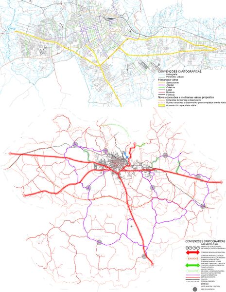
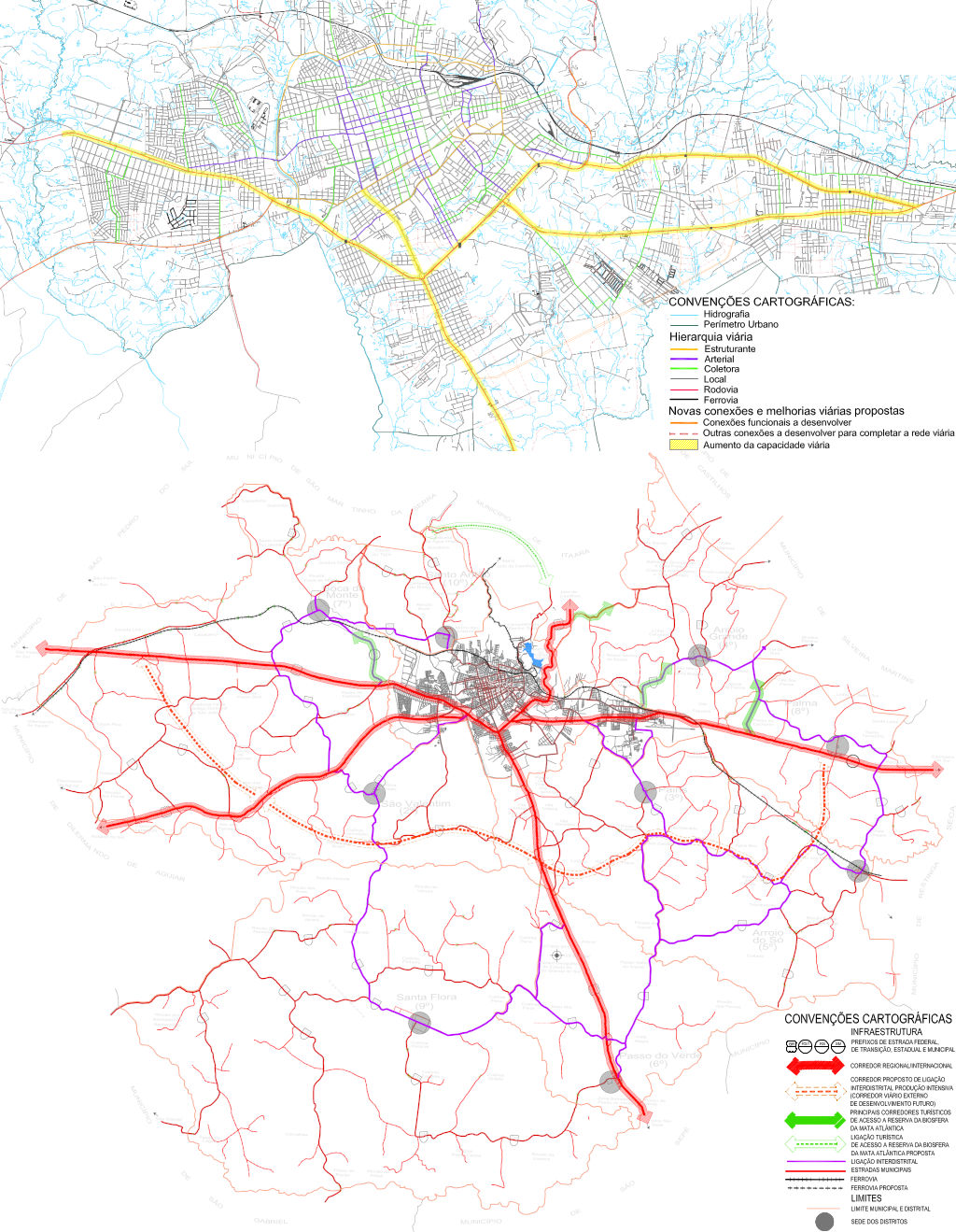
Classificação oficial segundo a lei de uso e ocupação do solo, publicada em 26 de julho de 2018.
Disponível oficialmente no site da Prefeitura em Sugestões PDDUA > Legislação, em:
- Lei de Uso e Ocupação do Solo > LUOS Anexos do 1 ao 26 exceto os anexos 6, 8 e 16
- Anexo 4: Mapa do sistema viário do município
- Anexo 14: Mapa do sistema viário Sede - 1º Distrito
- Plano Diretor de Mobilidade Urbana > Plano Diretor de Mobilidade Urbana - Outros Arquivos, relatório tecnico e anexos > Relatório técnico III > 5.4.2 Proposta de nova hierarquia viária > Imagens 81 e 82: Hierarquia viária proposta, pág. 106
Licensing
![]()
This file has been released into the public domain by the copyright holder, its copyright has expired, or it is ineligible for copyright. This applies worldwide.
Please, please use more specific template such as {{PD-self}} / {{PD-creator}} / {{PD-shape}} / {{PD-USGov}} / {{PD-old}} / {{PD-RU-exempt}} ... This template is not making clear why this work is in the public domain.
Please, please use more specific template such as {{PD-self}} / {{PD-creator}} / {{PD-shape}} / {{PD-USGov}} / {{PD-old}} / {{PD-RU-exempt}} ... This template is not making clear why this work is in the public domain.
File history
Click on a date/time to view the file as it appeared at that time.
| Date/Time | Thumbnail | Dimensions | User | Comment | |
|---|---|---|---|---|---|
| current | 14:24, 18 January 2021 | | 1,024 × 1,319 (366 KB) | Ftrebien (talk | contribs) | Atualizada para nova lei. |
| 20:42, 13 March 2018 |  | 1,024 × 1,573 (465 KB) | Ftrebien (talk | contribs) | Mapa da lei de uso e ocupação do solo tem uma classificação viária mais detalhada que a do plano diretor. | |
| 05:38, 2 October 2015 |  | 1,024 × 1,342 (464 KB) | Ftrebien (talk | contribs) | Classificação oficial segundo o plano diretor, publicada em 10 de abril de 2007. Disponível oficialmente no site da [https://www.caxias.rs.gov.br/ Prefeitura] em [http://www.santamaria.rs.gov.br/secao/documentos Documentos] > [http://www.santamaria... |
You cannot overwrite this file.
File usage
The following page uses this file: