File:Br-classificacao-sao-paulo-sp-plano-diretor.png
Jump to navigation
Jump to search

Size of this preview: 196 × 600 pixels. Other resolutions: 78 × 240 pixels | 157 × 480 pixels | 251 × 768 pixels | 1,024 × 3,133 pixels.
Original file (1,024 × 3,133 pixels, file size: 1.1 MB, MIME type: image/png)
Summary
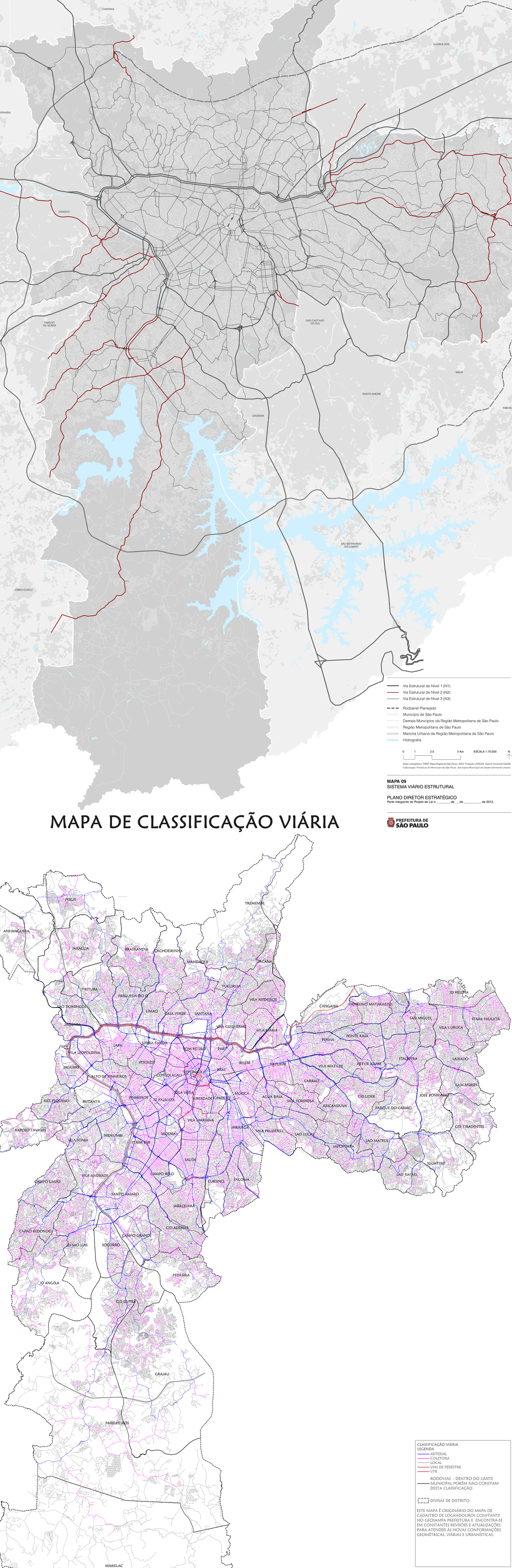
Classificação oficial segundo o plano diretor, publicada em 22 de setembro de 2013, e adequação periódica de trânsito da CET, publicada em 20 de abril de 2019.
Disponível oficialmente no site da Prefeitura, neste link direto em Mapa 9 - Viário Estrutural, e em Governo municipal > Encontre as secretarias > Mobildade e transportes > Companhia de Engenharia de Tráfego > Consultas > Classificação Viária > Mapa da classificação viária.
Licensing
![]()
This file has been released into the public domain by the copyright holder, its copyright has expired, or it is ineligible for copyright. This applies worldwide.
Please, please use more specific template such as {{PD-self}} / {{PD-creator}} / {{PD-shape}} / {{PD-USGov}} / {{PD-old}} / {{PD-RU-exempt}} ... This template is not making clear why this work is in the public domain.
Please, please use more specific template such as {{PD-self}} / {{PD-creator}} / {{PD-shape}} / {{PD-USGov}} / {{PD-old}} / {{PD-RU-exempt}} ... This template is not making clear why this work is in the public domain.
File history
Click on a date/time to view the file as it appeared at that time.
| Date/Time | Thumbnail | Dimensions | User | Comment | |
|---|---|---|---|---|---|
| current | 02:35, 21 June 2020 | 1,024 × 3,133 (1.1 MB) | Ftrebien (talk | contribs) | Classificação oficial segundo o plano diretor, publicada em 22 de setembro de 2013, e adequação periódica de trânsito da CET, publicada em 20 de abril de 2019. Disponível oficialmente no site da [http://www.capital.sp.gov.br/ Prefeitura], [neste link direto https://gestaourbana.prefeitura.sp.gov.br/novo-plano-diretor-estrategico/] em [Mapa 9 - Viário Estrutural http://gestaourbana.prefeitura.sp.gov.br/arquivos/mapas_pde/Mapas/09_Sistema_Vi%C3%A1rio/PDF.zip], e em Governo municipal > Encontre... |
You cannot overwrite this file.
File usage
The following page uses this file: