File:Br-classificacao-taubate-sp-plano-diretor.jpg
Jump to navigation
Jump to search


Size of this preview: 800 × 579 pixels. Other resolutions: 320 × 232 pixels | 640 × 463 pixels | 1,024 × 741 pixels.
Original file (1,024 × 741 pixels, file size: 257 KB, MIME type: image/jpeg)
Summary
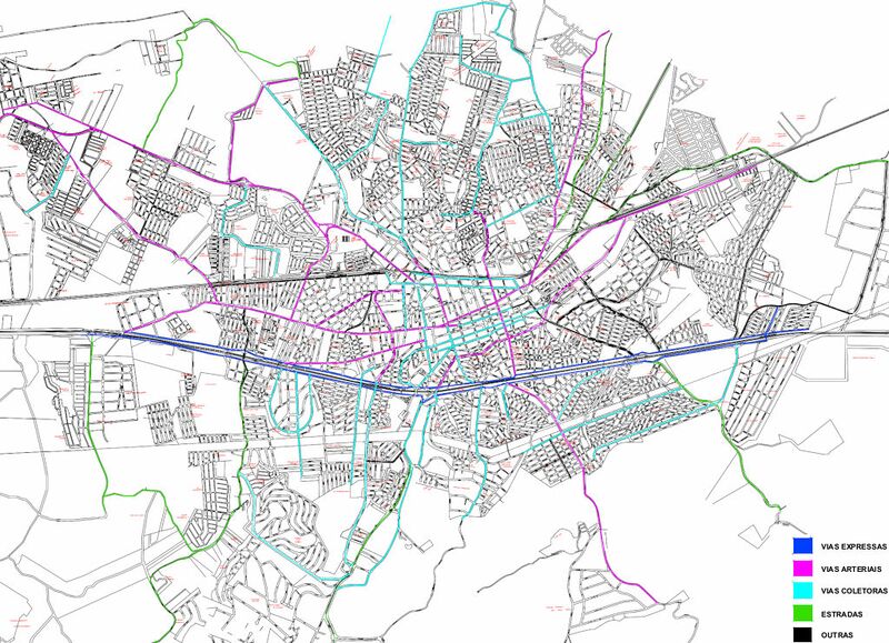
Classificação oficial segundo o plano diretor, publicada em 12 de julho de 2017.
Disponível oficialmente no site da Câmara em Legislação > Leis Municipais > Lei Complementar 412 > Lei Complementar Nº 412/2017 > arquivo digitalizado > Anexo XVII - Macroestrutura viária.
Licensing
![]()
This file has been released into the public domain by the copyright holder, its copyright has expired, or it is ineligible for copyright. This applies worldwide.
Please, please use more specific template such as {{PD-self}} / {{PD-creator}} / {{PD-shape}} / {{PD-USGov}} / {{PD-old}} / {{PD-RU-exempt}} ... This template is not making clear why this work is in the public domain.
Please, please use more specific template such as {{PD-self}} / {{PD-creator}} / {{PD-shape}} / {{PD-USGov}} / {{PD-old}} / {{PD-RU-exempt}} ... This template is not making clear why this work is in the public domain.
File history
Click on a date/time to view the file as it appeared at that time.
| Date/Time | Thumbnail | Dimensions | User | Comment | |
|---|---|---|---|---|---|
| current | 11:11, 2 December 2020 | | 1,024 × 741 (257 KB) | Ftrebien (talk | contribs) | Classificação oficial segundo o plano diretor, publicada em 12 de julho de 2017. Disponível oficialmente no site da [https://www.camarataubate.sp.gov.br/ Câmara] em Legislação > [https://www.camarataubate.sp.gov.br/legislacao Leis Municipais] > Lei Complementar 412 > [https://www.camarataubate.sp.gov.br/detalhe-da-legislacao/info/lei-complementar-412-2017/17888 Lei Complementar Nº 412/2017] > [https://www.camarataubate.sp.gov.br/abrir_arquivo.aspx/Lei_Complementar_412_2017?cdLocal=5&arquivo=... |
You cannot overwrite this file.
File usage
The following page uses this file: