File:Buildings aerial view.svg
Jump to navigation
Jump to search

Size of this PNG preview of this SVG file: 800 × 487 pixels. Other resolutions: 320 × 195 pixels | 640 × 389 pixels | 1,024 × 623 pixels | 1,280 × 779 pixels | 1,055 × 642 pixels.
Original file (SVG file, nominally 1,055 × 642 pixels, file size: 16 KB)
Summary
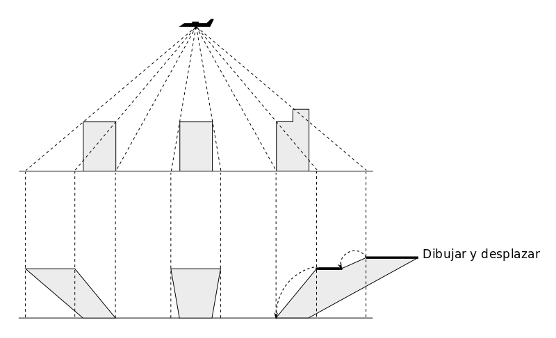
El contorno del edificio debe alinearse con el nivel del suelo, no con el techo visto en perspectiva en la ortofoto. Las partes del edificio siguen un proceso similar, empezando por el nivel más alto, alineando con el nivel inmediato inferior hasta llegar al nivel del suelo.
Licensing
![]()
This file has been released into the public domain by the copyright holder, its copyright has expired, or it is ineligible for copyright. This applies worldwide.
Please, please use more specific template such as {{PD-self}} / {{PD-creator}} / {{PD-shape}} / {{PD-USGov}} / {{PD-old}} / {{PD-RU-exempt}} ... This template is not making clear why this work is in the public domain.
Please, please use more specific template such as {{PD-self}} / {{PD-creator}} / {{PD-shape}} / {{PD-USGov}} / {{PD-old}} / {{PD-RU-exempt}} ... This template is not making clear why this work is in the public domain.
File history
Click on a date/time to view the file as it appeared at that time.
| Date/Time | Thumbnail | Dimensions | User | Comment | |
|---|---|---|---|---|---|
| current | 05:57, 6 December 2017 | | 1,055 × 642 (16 KB) | Javiersanp (talk | contribs) | Adjust paper size |
| 05:54, 6 December 2017 |  | 1,052 × 744 (16 KB) | Javiersanp (talk | contribs) | El contorno del edificio debe alinearse con el nivel del suelo, no con el techo visto en perspectiva en la ortofoto. Las partes del edificio siguen un proceso similar, empezando por el nivel más alto, alineando con el nivel inmediato inferior hasta ll... |
You cannot overwrite this file.
File usage
The following 2 pages use this file: