File:Costa Cruise OSM.jpg
Jump to navigation
Jump to search


Size of this preview: 800 × 600 pixels. Other resolutions: 320 × 240 pixels | 640 × 480 pixels | 1,024 × 768 pixels | 1,280 × 960 pixels | 2,592 × 1,944 pixels.
Original file (2,592 × 1,944 pixels, file size: 749 KB, MIME type: image/jpeg)
Summary
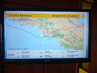
Costa Cruise using OSM for their maps.
This is a Featured image, which means that it has been identified as one of the best examples of OpenStreetMap mapping, or that it provides a useful illustration of the OpenStreetMap project. If you know another image of similar quality, you can nominate it on Featured image proposals.
Front-page image for week 49 of 2014 (1–7 Dec.).
- Image descriptions
- Deutsch : Passagiere von Costa-Kreuzfahrten können sich auf einer Vielzahl von Monitoren (in der Kabine, auf interaktiven Bildschirmen), die OpenStreetMap-Karten zeigen, den Fahrtverlauf der Schiffe ansehen.
- English : On Costa cruises, passengers can visualise the progress of the ships on many screens (inside the cabin, on interactive screens) featuring maps from OpenStreetMap
- italiano : I passeggeri delle crociere Costa possono visualizzare il progresso delle navi su molti schermi (dentro alla cabina, su schermi interattivi) con mappe basate su OpenStreetMap.
- русский : Установленные на круизных лайнерах «Коста» телевизоры в прямом эфире показывают процесс перемещения судна в пространстве. В основе карт — данные ОСМ.
- 中文(繁體) : 在歌詩達郵輪 (Cosata cruises)上,乘客能夠在船上各處的螢幕(在客艙裡的互動螢幕),看到航程的視覺化進度,用到的正是開放街圖的地圖。
Licensing
![]()
![]()
![]()
This work is licensed under the Creative Commons Attribution-ShareAlike 2.0 License.
Attribution not specified as a parameter! THIS LICENSE ALWAYS REQUIRES ATTRIBUTION! Use {{CC-BY-SA-2.0|Attribution, typically name of author}} See Template:CC-BY-SA-2.0 for full description how this template should be used.
Note, there is
There is also
Attribution not specified as a parameter! THIS LICENSE ALWAYS REQUIRES ATTRIBUTION! Use {{CC-BY-SA-2.0|Attribution, typically name of author}} See Template:CC-BY-SA-2.0 for full description how this template should be used.
Note, there is
{{CC-BY-SA-2.0 OpenStreetMap}} for files based on old OSM map data, before the license change made on 2012-09-12.There is also
{{OSM Carto screenshot||old_license}} for files based on old OSM map data, before the license change made on 2012-09-12, created using OSM Carto map style.
File history
Click on a date/time to view the file as it appeared at that time.
| Date/Time | Thumbnail | Dimensions | User | Comment | |
|---|---|---|---|---|---|
| current | 17:30, 1 November 2014 | | 2,592 × 1,944 (749 KB) | Fmorel (talk | contribs) | Costa Cruise using OSM for their maps. |
You cannot overwrite this file.
File usage
The following 6 pages use this file: