File:Illinois District 4 2004.png
Jump to navigation
Jump to search
No higher resolution available.
Illinois_District_4_2004.png (380 × 379 pixels, file size: 13 KB, MIME type: image/png)
This file and its description are from Wikimedia Commons.
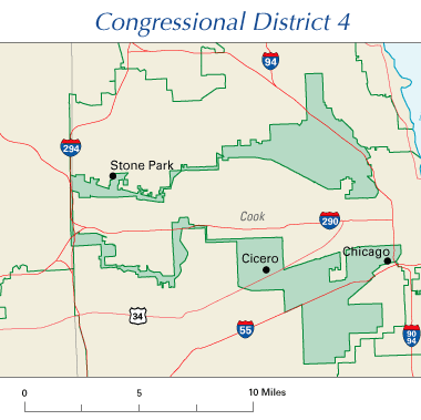
Illinois' 4th Congressional District, 108th Congress
Illustrates gerrymandering.
This map was obtained from an edition of the National Atlas of the United States. Like almost all works of the U.S. federal government, works from the National Atlas are in the public domain in the United States.
Online access: NationalAtlas.gov | 1970 print edition: Library of Congress, Perry-Castañeda Library
|
File history
Click on a date/time to view the file as it appeared at that time.
| Date/Time | Thumbnail | Dimensions | User | Comment | |
|---|---|---|---|---|---|
| current | 09:03, 26 July 2005 | | 380 × 379 (13 KB) | wikimediacommons>Scott Ritchie | Illinois' 4th Congressional District, 108th Congress {{PD-self}} |