File:Openfiremap colour.png
Jump to navigation
Jump to search


Size of this preview: 800 × 427 pixels. Other resolutions: 320 × 171 pixels | 640 × 342 pixels | 1,275 × 681 pixels.
Original file (1,275 × 681 pixels, file size: 2.49 MB, MIME type: image/png)
Summary
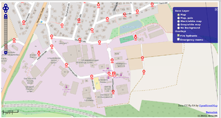
OpenFireMap Render with Mapnik colour / Zoom 17
Licensing
![]()
This file has been released into the public domain by the copyright holder, its copyright has expired, or it is ineligible for copyright. This applies worldwide.
Please, please use more specific template such as {{PD-self}} / {{PD-creator}} / {{PD-shape}} / {{PD-USGov}} / {{PD-old}} / {{PD-RU-exempt}} ... This template is not making clear why this work is in the public domain.
Please, please use more specific template such as {{PD-self}} / {{PD-creator}} / {{PD-shape}} / {{PD-USGov}} / {{PD-old}} / {{PD-RU-exempt}} ... This template is not making clear why this work is in the public domain.
File history
Click on a date/time to view the file as it appeared at that time.
| Date/Time | Thumbnail | Dimensions | User | Comment | |
|---|---|---|---|---|---|
| current | 11:07, 29 August 2015 | | 1,275 × 681 (2.49 MB) | Rza31 (talk | contribs) | OpenFireMap Render with Mapnik colour / Zoom 17 |
You cannot overwrite this file.
File usage
The following 2 pages use this file: