File:Rede Ferroviária Portuguesa (Agosto 2012).jpg
Jump to navigation
Jump to search
Size of this preview: 424 × 600 pixels. Other resolutions: 170 × 240 pixels | 339 × 480 pixels | 543 × 768 pixels | 724 × 1,024 pixels | 1,680 × 2,376 pixels.
Original file (1,680 × 2,376 pixels, file size: 565 KB, MIME type: image/jpeg)
Summary
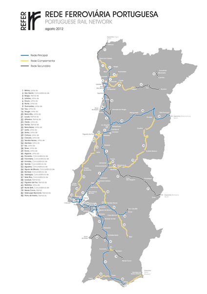
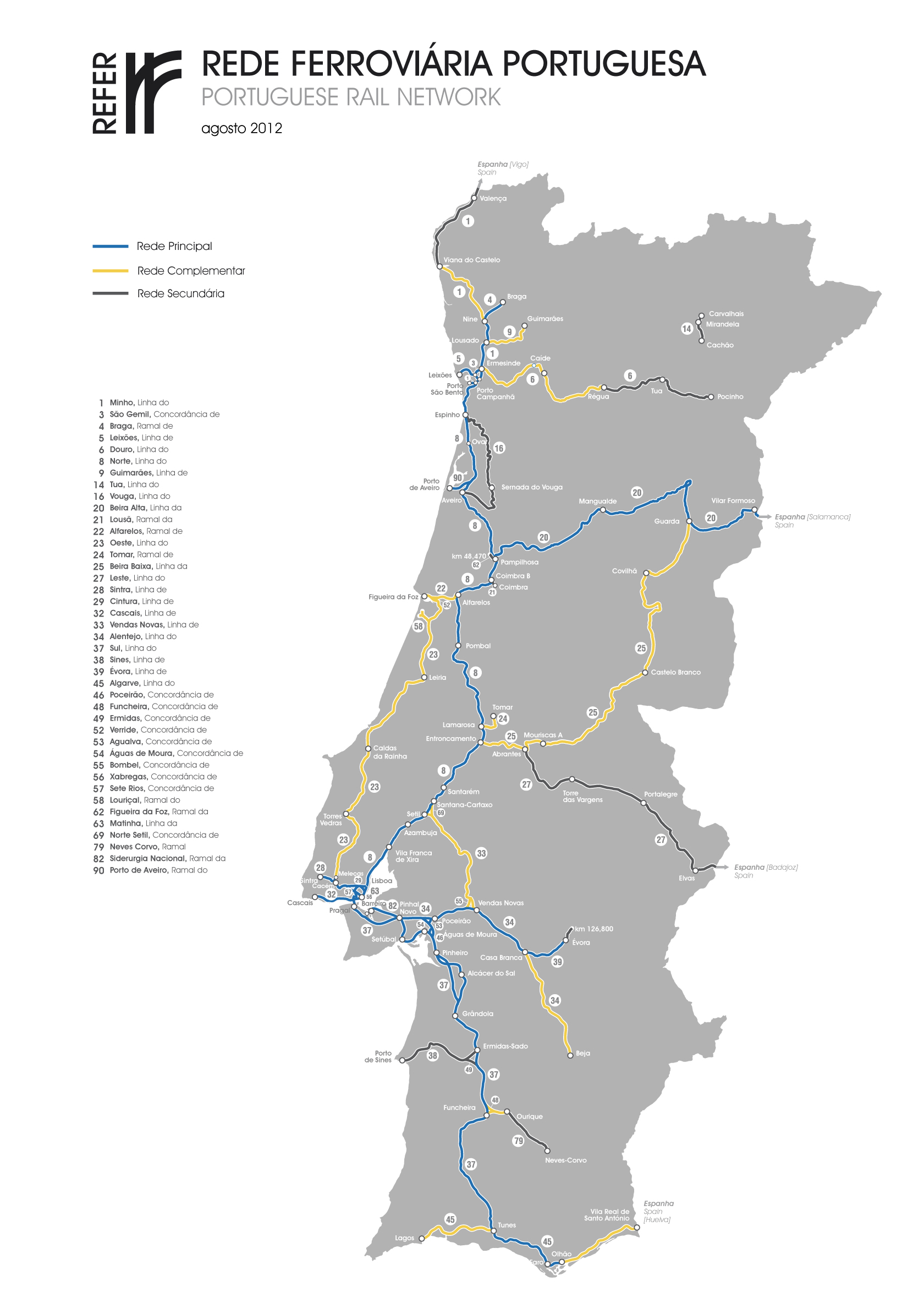
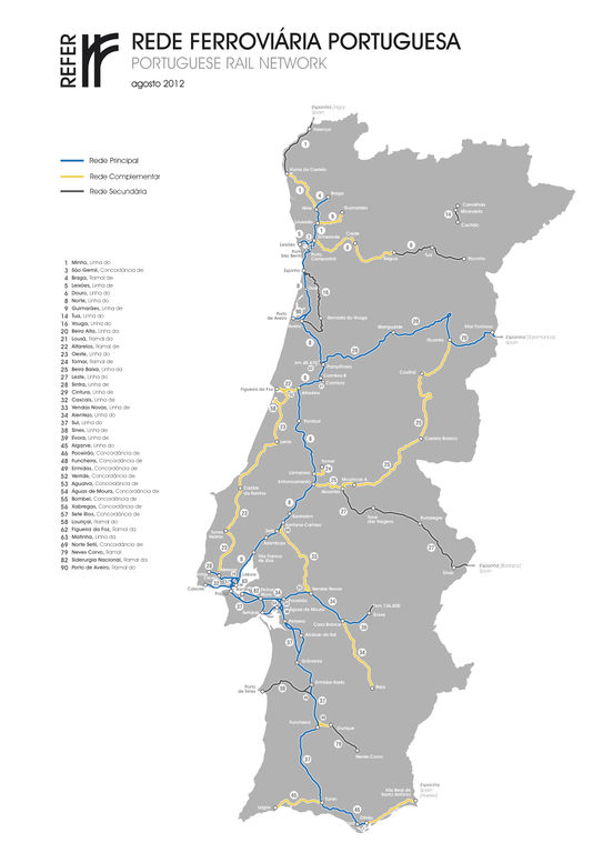
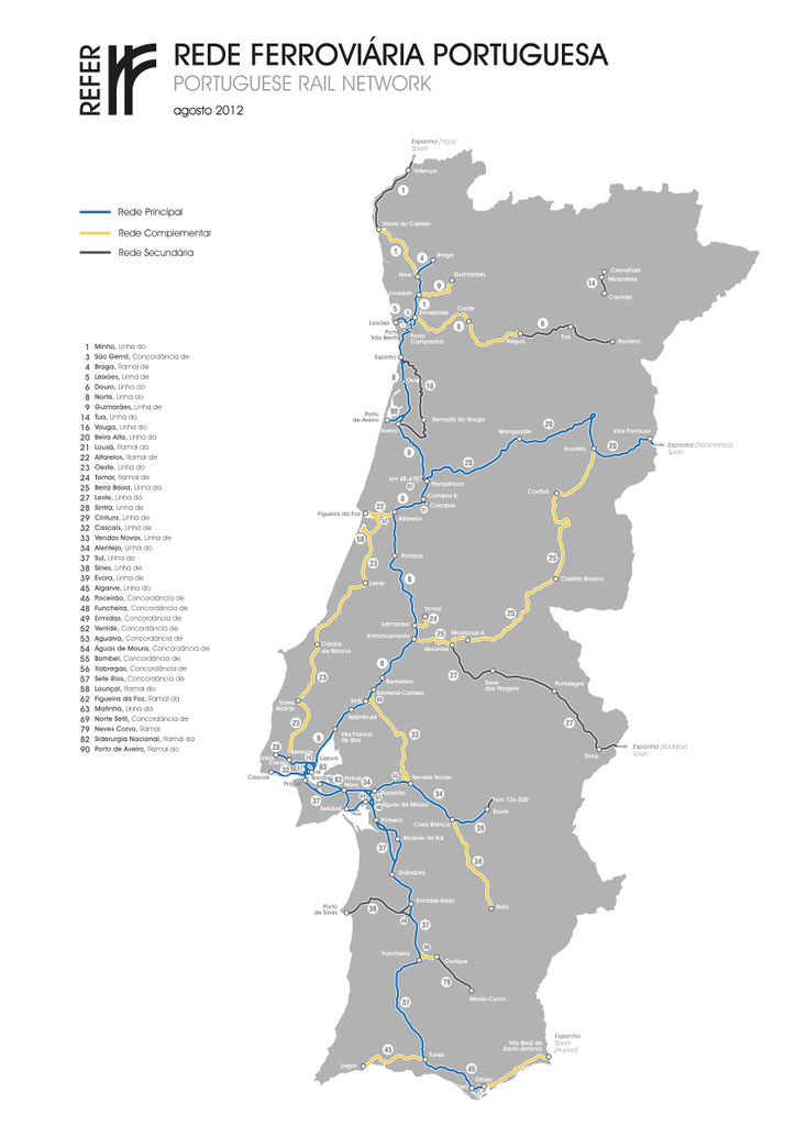
An illustration of the Portuguese rail network as of August 2012.
Rede Principal -> Main line
Rede Complementar -> Branch line
Rede Secundária -> Secondary line
Uma ilustração da rede ferroviária nacional portuguesa datada de Agosto 2012.
Licensing
![]()
![]()
![]()
This work is licensed under the Creative Commons Attribution-ShareAlike 2.0 License.
Attribution not specified as a parameter! THIS LICENSE ALWAYS REQUIRES ATTRIBUTION! Use {{CC-BY-SA-2.0|Attribution, typically name of author}} See Template:CC-BY-SA-2.0 for full description how this template should be used.
Note, there is
There is also
Attribution not specified as a parameter! THIS LICENSE ALWAYS REQUIRES ATTRIBUTION! Use {{CC-BY-SA-2.0|Attribution, typically name of author}} See Template:CC-BY-SA-2.0 for full description how this template should be used.
Note, there is
{{CC-BY-SA-2.0 OpenStreetMap}} for files based on old OSM map data, before the license change made on 2012-09-12.There is also
{{OSM Carto screenshot||old_license}} for files based on old OSM map data, before the license change made on 2012-09-12, created using OSM Carto map style.
File history
Click on a date/time to view the file as it appeared at that time.
| Date/Time | Thumbnail | Dimensions | User | Comment | |
|---|---|---|---|---|---|
| current | 23:32, 12 March 2014 | | 1,680 × 2,376 (565 KB) | ViriatoLusitano (talk | contribs) | An illustration of the Portuguese rail network as of August 2012. Rede Principal -> Main line Rede Complementar -> Branch line Rede Secundária -> Secondary line ---- Uma ilustração da rede ferroviária nacional portuguesa datada de Agosto 2012. |
You cannot overwrite this file.
File usage
There are no pages that use this file.
.jpg&oldid=2623141)