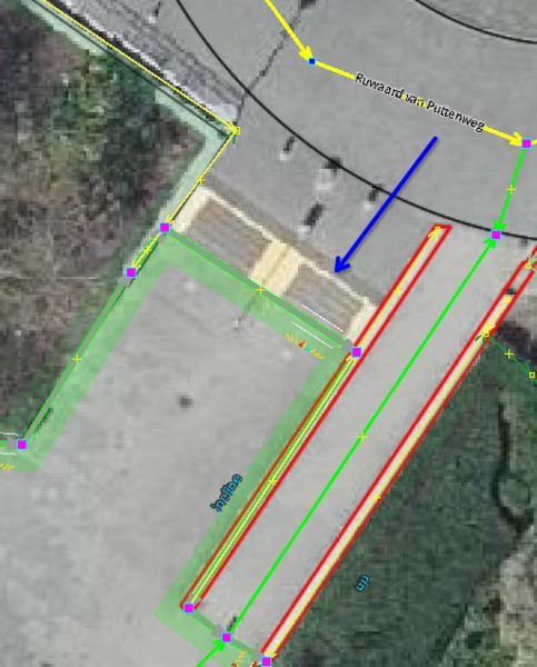
File:Steps in pedestrian area.png
Jump to navigation
Jump to search
Size of this preview: 483 × 600 pixels. Other resolutions: 193 × 240 pixels | 512 × 636 pixels.
Original file (512 × 636 pixels, file size: 176 KB, MIME type: image/png)
Summary
| Description | Steps in combination with a pedestrian area |
|---|---|
| Author | Emvee |
| Source | JOSM with PDOK Luchtfoto 2023 and BGT Omtrekgerichte visualisatie layers (Beeldmateriaal.nl) enabled |
| Date | 20231210 |
Licensing
![]()
This file is a screenshot of the software JOSM, with imagery in background. It may include OpenStreetMap data, in such case ODbL license also applies.
![]()
"JOSM" (Java OpenStreetMap Editor – josm.openstreetmap.de) is free software released under the terms of the GNU General Public License as published by the Free Software Foundation; either version 2 of the license, or any later version.
Imagery in background: CC-BY-4.0
| Contains map data © OpenStreetMap contributors, made available under the terms of the Open Database License (ODbL).
The ODbL does not require any particular license for maps produced from ODbL data, produced maps may be subject also to other licences. |
![]()
![]()
This work is licensed under the Creative Commons Attribution 4.0 License.
Attribution: PDOK/Beeldmateriaal.nl
Attribution: PDOK/Beeldmateriaal.nl
File history
Click on a date/time to view the file as it appeared at that time.
| Date/Time | Thumbnail | Dimensions | User | Comment | |
|---|---|---|---|---|---|
| current | 08:39, 10 December 2023 | | 512 × 636 (176 KB) | Emvee (talk | contribs) | {{Information | description=Steps in combination with a pedestrian area | source=Josm screen shot | date= | author=Emvee | other_versions= }} |
You cannot overwrite this file.
File usage
The following page uses this file: