File:Useless old imagery traced roads ghana.jpg
Jump to navigation
Jump to search


Size of this preview: 800 × 500 pixels. Other resolutions: 320 × 200 pixels | 640 × 400 pixels | 1,024 × 640 pixels | 1,531 × 957 pixels.
Original file (1,531 × 957 pixels, file size: 428 KB, MIME type: image/jpeg)
Summary
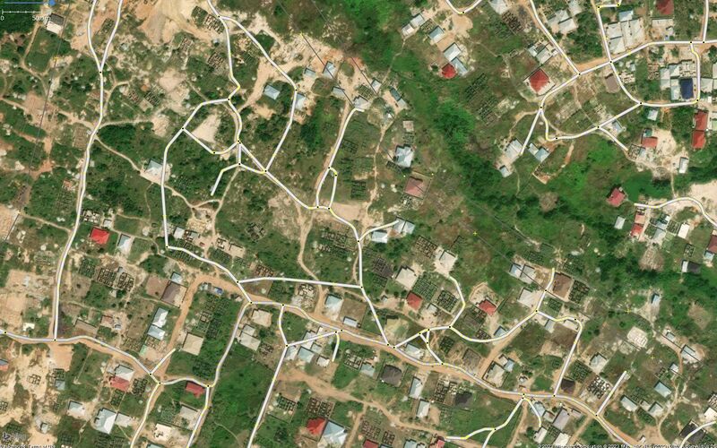
| Description | Example of useless roads resulting from use of old imagery in tracing roads in Ghana as result of organised mapping, view centered around https://www.openstreetmap.org/node/6008157244 |
|---|---|
| Author | Enock Seth Nyamador |
| Source | JOSM |
| Date | 2023-05-10 |
Licensing
![]()
![]()
This image is composed entirely, or almost entirely, of Bing aerial imagery.
Bing imagery is not open licensed, but is generously made available to the OpenStreetMap project for deriving open licensed map data in editors such as JOSM, iD or Vespucci. This upload is not covered by permission described at Bing Maps, as OSM Wiki cannot be interpreted as "editor application" and "We require you use access credentials to use the service and require use of transaction tracking and/or session tracking methods for all uses of the service" is not fulfilled.
This image is a relatively minor extract of the (worldwide) Bing imagery, used for illustrative purposes on the OpenStreetMap wiki, to help document ways of using and interpreting the imagery in the OpenStreetMap mapping process.
This image is a relatively minor extract of the (worldwide) Bing imagery, used for illustrative purposes on the OpenStreetMap wiki, to help document ways of using and interpreting the imagery in the OpenStreetMap mapping process.
File history
Click on a date/time to view the file as it appeared at that time.
| Date/Time | Thumbnail | Dimensions | User | Comment | |
|---|---|---|---|---|---|
| current | 22:25, 10 May 2023 | | 1,531 × 957 (428 KB) | Enock4seth (talk | contribs) | {{Information | description= Example of useless roads resulting from use of old imagery in tracing roads in Ghana as result of organised mapping, view centered around https://www.openstreetmap.org/node/6008157244 | source= JOSM | date= 2023-05-10 | author= Enock Seth Nyamdor | other_versions= }} |
You cannot overwrite this file.
File usage
The following page uses this file: