User:Enock4seth/Deleting several highway=* in Ghana
Jump to navigation
Jump to search
This page is to document mass deletion or replacement (when possible) of roads in Ghana.

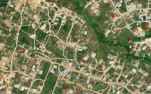
Example of useless roads resulting from use of old imagery in tracing roads in Ghana as result of organised mapping, view centered around https://www.openstreetmap.org/node/6008157244
History
There have been several roads mapped in Ghana from 2017 onward from Organized Mapping by mappers working for Apple. Over the years other mapping teams have also contributed to these such Bolt and TomTom. Also over enthusiasm from HOTOSM remote mappers and YouthMappers organisations. The imagery available at the time of massive highway=* (mostly highway=residential and overwhelming highway=path) mapping was very out of date, resulting a lot of non-existing roads in Ghana. In 2023, recent imagery have become available, unleashing lot of useless data.
ToDos
- DONE: Notify Talk-GH - https://lists.openstreetmap.org/pipermail/talk-gh/2023-May/000649.html
- TODO: Pre- and Post- clean up images
- TODO: Table/List of places and completion percentage
- TODO: Procedure