File:Viales con áreas adyacentes.jpg
Jump to navigation
Jump to search


Size of this preview: 800 × 447 pixels. Other resolutions: 320 × 179 pixels | 640 × 358 pixels | 1,280 × 715 pixels.
Original file (1,280 × 715 pixels, file size: 155 KB, MIME type: image/jpeg)
Summary
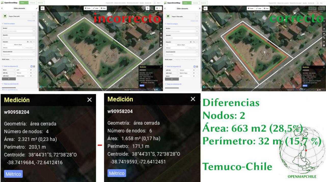
| Description | English: Comparison between two ways of mapping areas adjacent to highways, with common nodes (wrong) or leaving a space between the area and the highways (right). Español: Comparativa entre dos formas de mapear áreas adyacentes a vías de circulación (viales), con nodos comunes (incorrecto) o dejando un espacio entre el área y las vías de circulación (correcto). |
|---|---|
| Author | Paul Dassori |
| Source | Own work |
| Date | 2019-07-09 |
Licensing
ISC
Screenshot of iD editor. It may contain different content with different licensing.
The iD editor software is published under ISC License – Copyright iD Contributors.
The iD editor software is published under ISC License – Copyright iD Contributors.
Permission to use, copy, modify, and/or distribute this software for any purpose with or without fee is hereby granted, provided that the above copyright notice and this permission notice appear in all copies.
THE SOFTWARE IS PROVIDED "AS IS" AND THE AUTHOR DISCLAIMS ALL WARRANTIES WITH REGARD TO THIS SOFTWARE INCLUDING ALL IMPLIED WARRANTIES OF MERCHANTABILITY AND FITNESS. IN NO EVENT SHALL THE AUTHOR BE LIABLE FOR ANY SPECIAL, DIRECT, INDIRECT, OR CONSEQUENTIAL DAMAGES OR ANY DAMAGES WHATSOEVER RESULTING FROM LOSS OF USE, DATA OR PROFITS, WHETHER IN AN ACTION OF CONTRACT, NEGLIGENCE OR OTHER TORTIOUS ACTION, ARISING OUT OF OR IN CONNECTION WITH THE USE OR PERFORMANCE OF THIS SOFTWARE.![]()
![]()
This image is composed entirely, or almost entirely, of Bing aerial imagery.
Bing imagery is not open licensed, but is generously made available to the OpenStreetMap project for deriving open licensed map data in editors such as JOSM, iD or Vespucci. This upload is not covered by permission described at Bing Maps, as OSM Wiki cannot be interpreted as "editor application" and "We require you use access credentials to use the service and require use of transaction tracking and/or session tracking methods for all uses of the service" is not fulfilled.
This image is a relatively minor extract of the (worldwide) Bing imagery, used for illustrative purposes on the OpenStreetMap wiki, to help document ways of using and interpreting the imagery in the OpenStreetMap mapping process.
This image is a relatively minor extract of the (worldwide) Bing imagery, used for illustrative purposes on the OpenStreetMap wiki, to help document ways of using and interpreting the imagery in the OpenStreetMap mapping process.
![]()
![]()
This work is licensed under the Creative Commons Attribution 3.0 License.
Attribution: Paul Dassori
Attribution: Paul Dassori
File history
Click on a date/time to view the file as it appeared at that time.
| Date/Time | Thumbnail | Dimensions | User | Comment | |
|---|---|---|---|---|---|
| current | 00:35, 9 July 2019 | | 1,280 × 715 (155 KB) | Dcapillae (talk | contribs) | Comparativa de las dos formas de mapear áreas adyacentes a vías de circulación, con nodos comunes (incorrecto) o dejando un espacio entre el área y las vías de circulación (correcto). |
You cannot overwrite this file.
File usage
There are no pages that use this file.