FlightGear


FlightGear (FlightGear.org, ![]() FlightGear) is an open source flight simulator. Since November 2013, the official scenery of the simulator makes use of OSM line data. Buildings, roads, and objects for the entire world were generated and integrated into the official scenery in March 2021, creating a 3d visualisation of OSM data. This OSM world-scenery is automatically downloaded as you fly by FlightGear 2020.3.7 LTS [1] and later.
FlightGear) is an open source flight simulator. Since November 2013, the official scenery of the simulator makes use of OSM line data. Buildings, roads, and objects for the entire world were generated and integrated into the official scenery in March 2021, creating a 3d visualisation of OSM data. This OSM world-scenery is automatically downloaded as you fly by FlightGear 2020.3.7 LTS [1] and later.
Details
The official scenery provides global coverage, by using a variety of data sources, including NASA's 3-arcsec SRTM data, GSHHS data and Corine Land Cover.
Buildings, aerials, etc. are placed according to obstructions data etc. See the FlightGear Scenery Object Database for some examples.
OpenStreetMap buildings and objects
Buildings, roads, power cables/pylons, railways, railway platforms, piers, and other man-made objects, as mapped in OSM, can be turned into 3D models for use in FlightGear scenery. This is done with a custom written python script. More information at the FlightGear wiki.
Buildings and objects for the entire world were generated for FlightGear 2020.x, and integrated into the official scenery which is automatically downloaded as you fly by FlightGear 2020.3.7 LTS and later.
Generated objects for countries and regions also available for download for FlightGear 2017.2 and later.
External links
- http://wiki.flightgear.org/Terragear_Corine - Howto about Building Europe scenery with SRTM v4, Corine landclass and OpenStreetMap data
- http://forum.flightgear.org/viewtopic.php?f=5&t=9737 - Forum topic about building from OSM data
Gallery (old work)
2005 - 2011
Click on the image to enlarge.
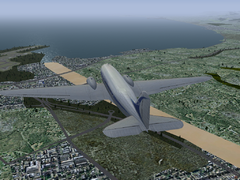
Scenario in Nice - 2011 work.
Location on OSM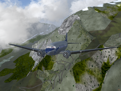
Winding in the Alps - 2011 work.
Location on OSM
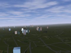
2005 work. Flying over London!
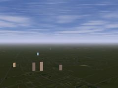
2005 work. Street maps in a flight sim


External links
- TerraGear Corine - Howto about Building Europe scenery with SRTM v4, Corine landclass and OpenStreetMap data
- Tutorial: Building Europe scenery - Forum topic about building from OSM data
References
- ↑ https://wiki.flightgear.org/Changelog_2020.3#2020.3.7 - Changelog for FlightGear 2020.3.7