GeoLogger
| GeoLogger | |
|---|---|
 | |
| Author: | SITIS |
| License: | Free? |
| Platform: | symbian OS 9.3 |
| Version: | 1.0 (2010-10-28) |
| Languages: | English and rus |
| Website: | |
|
Tracks, geophoto and navigation. Currently offline! | |
GeoLogger is a software designed to collect data to .strk file or gpx-file(write tracks for openstreetmaps or google earth and other program) and to map data from accelerometer detectors, GPS, magnetometer, as well as charge level and current time from the cell phone. It can be used for viewing of program tracks on the map, grid navigation, photomapping of objects during track recording or without track recording (with entering corresponding notes into the track), it also enables viewing of photos taken earlier and viewing of photos and shooting parameters on the map.
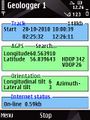
Logger
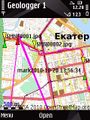
Map
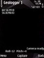
Camera


Download: http://rapidshare.com/files/431744781/GLS-1-101-1045-setup_Express_Signed.sis Currently offline!