Ground truth
Ground truth has several possible meanings:

- It may refer to "Map what's on the ground" good practice about on the ground situation being more important than official source.
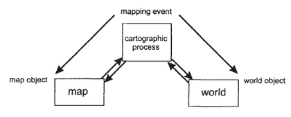
- “Ground truth” is a phrase used in cartography and sometimes within the OpenStreetMap community (where it is better known as "truth on the ground" or "TotG"), to mean collecting data on the ground, on location. More specifically it can refer to doing this in order to get reference points for positioning aerial imagery data (or data traced from it). You might describe this as "ground truthing" the data, or just "grounding" it. See also Good practice#Map what's on the ground, quality assurance and accuracy. See Wikipedia's article.
versus 'official truth'
Sometimes there is no meaningful interpretation of 'ground truth'. A typical example would be in some cases of unsigned administrative boundaries, that are "areas/territories/jurisdictions recognised by governments", there are a "official recognition" of the Map Feature, not a Ground truth recognition. The existence and "The Truth" of this kind of Map Feature is confirmed by official documentary evidence, as official Law text or official agreement of ownership... The Official truth, with few or no data to collect on the ground.
Summarizing, they are two complementary concepts:
- Ground truth: is the empirical evidence, the geographic reality. It is collected on location or proofs of existence like satellite images.
- Official truth: is the (official) documentary evidence, offered by Law. It is collected on location's jurisdiction. The jurisdiction's sovereignty and hierarchy (e.g. administrative levels) are recognized by the OSM Community. The sources cited as official evidence (of a specific Map Feature) is also subject to OSM Community acceptance.
Ground truth and official truth can in some cases be tagged complementarily. For example, on the same feature, one can simultaneously map both the ground-truth name as name=* and the official-truth name as official_name=*. This enables data consumers to decide which truth better suits their particular use case - or use them both.
(See also WikiProject Brazil/Oficial)
other meanings
If an internal link led you here, you may wish to change the link to point directly to the intended article.
- GroundTruth is a software tool for Windows (.NET) to produce maps for Garmin GPS devices.
- GroundTruth Initiative (groundtruth.in) is a small technology consulting company directed by Mikel Maron and Erica Hagen, working on OpenStreetMap mapping and citizen journalism projects in poor and marginalized regions throughout the world, such as mapkibera.org.
- “Ground truth” is also some kind of internal codename for mapping party ideas by the Google Map Maker team.