Nepal/Humla/Trails and Local Infrastructure Mapping
Project overview
This project is focused on collection of local trails and infrastructure data in Humla using GPS and OSM mapper tools, uploading to OpenStreetMap and preparation of municipality wise map books. Local people were trained to use GPS to track the trails. The end product is the data uploaded in OSM as well as map books for the local government. The local areas suffer from lack of electricity and internet so paper based maps are more useful in-situ. The project was handled by NAXA with the support of WFP Nepal (World Food Programme). It was funded by Australian Aid, under the Emergency Preparedness and Response Project. The project was implemented by the WFP in cooperation with the Nepal Ministry of Home Affairs. Preparedness and capacity development initiatives are being carried out by the ministry in Karnali and Sudurpaschim Province. The project was carried out from march 2019 to feb 2020.
Goals
- Map local trails and infrastructures on OpenStreetMap (OSM).
- Carry out a gap analysis study on the existing data collection methods, availability of spatial information regarding accessibility and local infrastructures, which are critical during humanitarian emergencies.
- Sensitize the local level representatives, community members and relevant stakeholders in Humla on the significance of spatial data, open data and open mapping platforms like OSM in Emergency preparedness & response, disaster management and development planning.
- Train the local level representatives, government officials and relevant stakeholders on the use of OSM and spatial data collection tools like Global Positioning System (GPS), and OSMTracker.
- Address the data gap across local units in Humla by mobilizing locals in collecting and updating spatial data of major trails and local infrastructures.
Project Method
- Remote Mapping: The remote mapping sessions were conducted with a group of around 10 map enthusiasts. They were trained in OSM beforehand by a frequent OSM mapper. The remote mapping was done in JOSM, an offline OSM editing tool.
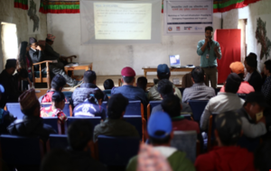
- Sensitization workshop: A half day orientation session was organized at the District Coordinator's office, humla on September 4, 2019. 56 participants from 23 different organizations attended the orientation. Gaps in current map was analysed and list of trails was shares with all the participants. In the end, a definite set of trails were finalized to be surveyed.
- OSM Training: 5 trainers organized a 4 days technical training on use of digital data collection tools and mapping using OSM. 25 participants (3 females and 22 males) were selected for the training. The participants were from different organizations including municipal office staff, OJTs, representatives from security forces, Red Cross Society, DDC, DCC, Infrastructure Development Office and other agencies. The training included theory sessions with presentations, practical sessions with OSM and JOSM exercise and tasks and group trail exercise for GPS and OSM tracker survey.
- Field Survey: Five teams were formed consisting of three individuals in each team with one team leader (mapping expert). GPS devices, OSMTracker application and field books were used by each group to record the data during field survey. Data captured using GPS trackers and OSMTracker app were cross verified. The teams walked for a total of 69 days collecting data.Teams collected following information.
| S.N. | Category | Layers |
| 1 | Trail networks | Trails with linking settlements, trail junction, separated trails according to narrow sections, accessibility, and so on |
| 2 | River crossings | Log crossing, stone crossing, timber bridge, truss bridge, suspended bridge |
| 3 | Health amenities | Health posts, clinics, hospitals, birthing centers |
| 4 | Public buildings | Municipality and ward offices, security offices, NGO/INGO |
| 5 | Community spaces | Open spaces, potential helicopter landing zones, storage and shelter zones, existing helipads |
| 6 | Business centers | Market centers, bazaars, Haat bazaars |
| 7 | Obstacles | Damaged section, stream crossing, gullies, boulders and other obstacles |
| 8 | Hazards | Landslides, soil slumping, erosion, rock falling areas |
| 9 | Financial institutions | Bank, cooperatives, microfinance |
| 10 | Utility infrastructures | Public taps, public toilets, reservoir tanks, hydropower, mill |
| 11 | Settlements | Village clusters, local name of settlements |
| 12 | Education infrastructures | Basic, secondary, higher secondary schools, college, kindergarten |
| 13 | Other geographical features | Mountain passes, kharkas, river names, community structure, stream, cliff and viewpoint. |
- Data cleaning and validation: For the data cleaning and validation process a team of GIS officers was formed. The data from GPS and OSMTracker were overlaid in the base map in JOSM, Bing Aerial Image was used as the base map and with reference to this all the data cleaning was performed. Standard tagging process was followed as per the standards available in OSM tagging guidelines.
- Geodatabase preparation and GIS Mapping: The cleaned data was then uploaded to OSM. For changeset comment the following hashtags were used #humlamapping #naxa #trailsmapping #wfp. Map books were prepared for each gaunpalika. Map books include thematic maps, demographic details, prepared maps and lists of data collected along with attribute details.
Results:
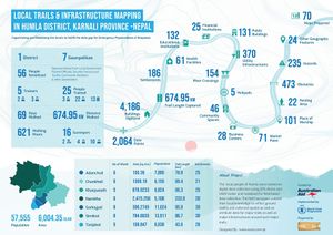
674.95 km of local trails were mapped. In a span of 22 days, the field survey team walked for about 621 hours. All Gaunpalikas in Humla were covered and significant local infrastructure was mapped along with their important attributes along the identified major trails. A total of 2064 POIs werecollected during the field work.
Video: [1]

