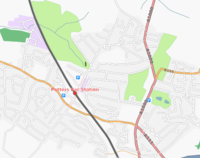
Potters Bar
Jump to navigation
Jump to search
| V・T・E |
| latitude: 51.697, longitude: -0.19 |
| Browse map of Potters Bar 51°41′49.20″ N, 0°11′24.00″ W |
| Edit map |

|
|
External links:
|
| Use this template for your locality |
Potters Bar is a town in Hertfordshire at latitude 51°41′49.20″ North, longitude 0°11′24.00″ West.
A customised version of the map can be seen at the Dame Alice Owen's School website:
The creation process for this special map was as follows:
- Osmarender 3 used to create SVG file from the database. Specifically designed for 645px width display (to also fit printed A4 page output).
- The standard Osmarender rules file was edited to:
- give appropriate road widths and casings for planned size
- lettering sizes adjusted to fit these new widths
- the tone for residential areas darkened
- The resulting SVG file was imported into Inkscape, so as to:
- Remove - clashing/small road names; some peripheral road detail
- Change - feature names to bolder (golf, park, Tesco, etc); position of 2 logos and scale bar
- Add - credit line; school (block and name); 2 oneway arrows; and junction number for M25
- The Inkscape file was saved as PNG and converted to JPG for web use.
