Project Ilam specification
Description
This page contains all the technical information about the mapping procedure, Tags, feature recognition,and some bad mapping examples for pilote project: Ilam_District
Techniques
Mappers from Western countries (people who are remotely mapping) on the project should focus on the geometry development (Point, Line, Polygon) with highest possible spatial accuracy. People nearby or at Nepal (Local People) should Name the features and add other important attributes of the spatial data. Progress of geometry data as well as attribute information should be updated together. The collaboration of International mappers and local people makes the complete map because only geometry or the only text can never give complete information.
The positioning reference for drawn objects is Bing.
Under http://mapcraft.nanodesu.ru/pie/651# you can reserve one or more slices to map, which help us to coordinate mapping progress.
Precision
- Desidered precision regarding areas: Mapping accuracy should be less than size of common village building.
- Desidered precision of ways: Ways with the class higher than truck may not leave the area of the street.
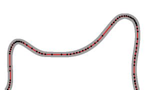
Example for ways:
 Bad example, steet midline outside of street area.

 Preffered mapping.

 Too many points.

Recognition of Elements from aerial images
Buildings
All buildings, even very small one have to be mapped.
Reason: Nepal doesn´t have precisely information about number of citizen in one area. Estimation by use of number of buildings is possible. Small buildings near bigger buildings (living houses) are mostly agriculture related buildings. As much such, sheds like, buildings as much estimated harvest (food production). More food produced means more people who benefit from it.
Indirectly, but relatively reliably, one can conclude from the number of small buildings to the number of people in a region.
Schools
Schools in rural areas have mostly following characteristics:
- Directly near way
- 2,3 or sometimes four longer buildings but the building width is not much bigger than typicall village house.
- 1 or 2 very small buildings near main buildings (school toilets)
- Completely trodden surface (school playground) - should be mapped as landuse=sand

Schools are often living centrum of village, it´s probably helpful to put the tagging of village name near of school area. Exception: When the school is outside of village centrum.
Farmland borders
If there are good visible natural borders of farmlands, please collect it as separate areas. Nepal doesn´t have in rural areas digital cadastrial map, OSM can be used instead of it.
Natural elements
Tea Plantage
Characteristic: olive dark green mostly. Homogene colour from the top view.
Example from aerial view:

Tagging:
- landuse=farmland
- crop=tea
 Mapped area
Terraced Farmland
Common in lot of agriculture areas in Nepal is terraced farmland. Often between terraces one may see irregular trees. Such areas are not natural=crop.

In Reality:

Mapped:

Tagging:
- landuse=farmland
- farmland=terraced
- trees=yes
Forest verus Scrub?
Scrub is area with less density of trees. The terrain is more visible than crown of trees.

In reality

Boundaries:

Tagging:
Scree
Sometimes it´s difficult to distinguisch between natural=scree and natural=sand.
Scree is significantly less homegen. Singular stone blocks are good visible in highest zoom level:
http://www.openstreetmap.org/way/484463110#map=15/26.8430/88.0450
Sand
there are two kinds of sand areas in Nepal. Artificial, like here:
http://www.openstreetmap.org/way/498904736
Mostly areaa of schools where the children are playing or local market places.
and natural like:
http://www.openstreetmap.org/way/487911300#map=14/26.7598/88.0751
Grassland
natural=grassland are areas covered mostly with grass, like:
http://www.openstreetmap.org/way/483156773
Orchard
An example: http://www.openstreetmap.org/way/506333419 Orange tree orchard in Manakamana.
What not to do

- Too big landuse=residential
- No landuse=farmland
- Wrong positioning and some wrong shapes of buildings
- Wrong positioning of ways