In cities, does the width of a street include the pedestrian area, or is it only the car/bicycle area?
Very good question! consensus should be settled about this confusing point! --Bremy 02:02, 27 July 2013
To me the tag width specifies the width of the carriageway and does not include the sidewalks. --Imagic (talk) 07:56, 30 July 2013 (UTC)
To me, on the other hand, the tag width represents the width of everything represented by the way tagged with it, which does include sidewalks if sidewalk=* is set. --Tordanik 10:38, 30 July 2013 (UTC)
feet
There is no documentation on whether to tag it as "feet", "ft", "ft." or whatever. I fully agree that there is nothing wrong with specifying the unit, but it is not yet defined how we specify it. This obviously affects maxwidth/-height/-length and height, too. --Tordanik 13:58, 10 September 2009 (UTC)
I would say that “ft” or “feet” are fine. Probably ′ (prime symbol) and ' (typewriter apostrophy) are not. Perhaps we need to start a “standard abbreviations” page – or is there some external list we can reference? --Hawke
See Map Features/Units. I'd say use "feet" or "ft" interchangeably with decimals, which should be fairly practical since most road signs will probably display to the nearest 3" anyway to keep things simple, and even I can convert that in my head. If you absolutely must use an exact feet and inches measurement, then you can still use the old-fashioned N'N" notation. Most people will use U+0027 APOSTROPHE (') and U+0022 QUOTATION MARK (") rather than U+2032 PRIME (′) or U+2033 DOUBLE PRIME (″), or any fancy curly quotes because they're easier to type. --achadwick 10:14, 16 June 2011 (BST)
Defining narrow
I'm trying to achieve consensus with defining "narrow". Feel free to participate. --Kslotte 12:44, 18 February 2010 (UTC)
Area
I can denote the length and the with of a feature, but how do I denote the area of a feature? I cannot use Key:area as it have a different purpose, but how do I do? --Magol (talk) 15:04, 24 July 2017 (UTC)
The best way to do this is to draw the object itself as a polygon, so the area can easily be calculated. It might still be useful to have such a tag for node features, but I'm not aware if any exists. --Tordanik 15:11, 24 July 2017 (UTC)
But even if I draw a polygon, it may be interesting to enter the exact area. It is not uncommon that the area for something is known, and it would have been useful if it was possible to specify that. --Magol (talk) 17:32, 24 July 2017 (UTC)
"width" on streets/highway
As a result of this discussion on the Tagging Mailing List, I would like to add the following paragraph under the heading "Width of streets" to address the widespread confusion about this. Are there any comments, suggestions or language corrections?--Supaplex030 (talk) 13:36, 21 September 2020 (UTC)
Since the discussion was still continuing, I modified my proposed paragraph. If there is no veto or suggestions, I would add it to the page soon.--Supaplex030 (talk) 20:21, 3 October 2020 (UTC)
It is controversial how to define the width of roads if the road includes elements such as sidewalks or parking lanes. Some mappers define width from curb to curb (including parking lanes if they are on street), others define the effective width of the carriageway or even the whole cross-section including side paths.
To avoid these ambiguities, some tags are in use to specify the width of different elements:
width:carriageway=* for the width of the entire carriageway (from curb to curb or edge to edge, including parking lanes if they are on street),
The effective usable width of the carriageway (the width of the area on which vehicles move in flowing traffic) can be determined either from width:carriageway=* minus any existing parking lanes (see the parking:lane=* scheme) or from the use of width:lanes. width:effective=* is rarely used to specify this. However, with or without markings, relocated vehicles, etc. it is unclear where the exact limit for measuring the effective width is located.
Consider using est_width=* if you can only estimate the width.
Methods to Map Width
Would be awesome to add a topic on here on how people go about collecting width data for roads. Are there JOSM plugins to be aware of? Is there a way to 'guestimate' using satellite imagery the width of roads/sidewalks? Anyone with more knowledge than me should provide some input. --IanVG (talk) 20:53, 4 March 2021 (UTC)
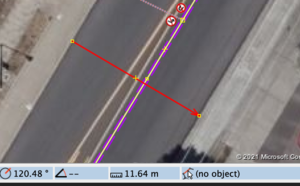
You can create a way in JOSM across the width of the feature, and this will show you the estimated width at the bottom of the screen, see example.
The red line across the road is a way which I created from kerb to kerb (easy to see here because the carriageway is asphalt and the kerbs are concrete), and JOSM estimates this as 11.64 meters. --Jeisenbe (talk) 07:34, 5 March 2021 (UTC)
Wow, this is perfect! Thank you for your contribution and time. Would you mind @Jeisenbe: if I added your instructions and picture to the page here? --IanVG (talk) 22:37, 6 March 2021 (UTC)
Mapping Examples
I think some examples illustrating what some width cases could look like in the real world would help people understand the methodology here. --IanVG (talk) 03:25, 5 March 2021 (UTC)
How frequently along a way should width be measured?
As many ways have variation in their width, how frequently along the way would you recommend surveying width? Would you opt for average width along a way - after say 10 measurements, width of the narrowest points eg. at a bottleneck? It would be good to gauge the approach used among the community as this is not otherwise documented. Thanks | Olivia.ragone 12/01/2024 09:58:01 (GMT)
I'd use the minimal widths as this seems to be the most relevant information for routers. --Martianfreeloader (talk) 11:12, 12 January 2024 (UTC)